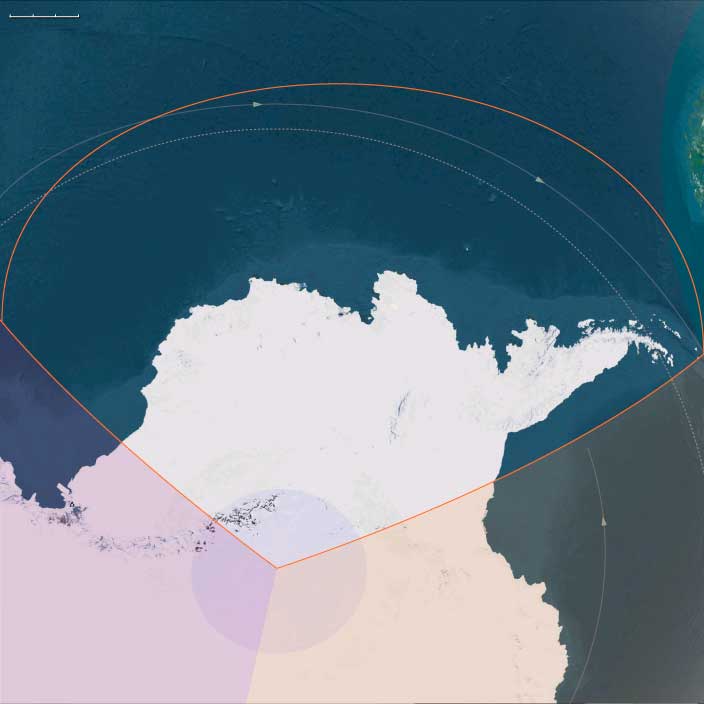
West Antarctica
Region
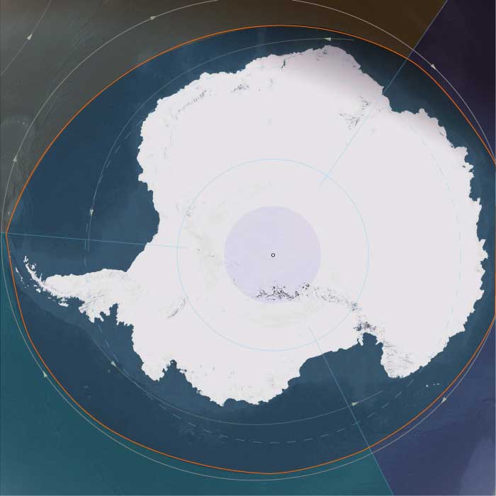
Antarctica
View →Related Events
Showing 10 events out of 38 total
Antarctica (49,293–28,578 BCE): Upper Pleistocene I — The Frozen Continent and Its Oceanic Halo
Geographic and Environmental Context
During the height of the Late Pleistocene, Antarctica stood as the coldest, driest, and most isolated world on Earth—a continent sealed in ice and girdled by the Southern Ocean.
The great landmass divided naturally into three broad realms:
-
East Antarctica, the immense polar plateau rising more than 3 km above sea level, draped in ice more than 4 km thick and stretching from the Transantarctic Mountains to the Indian Ocean rim.
-
West Antarctica, a lower, fractured terrain comprising the Antarctic Peninsula, Marie Byrd Land, and the Amundsen–Ross embayments, fringed by vast floating shelves.
-
The subantarctic ring—the nearby island arcs of South Georgia, the South Orkneys, the South Sandwich Islands, Bouvet, and the Prince Edward–Marion chain—sat just beyond the continental ice but within its climatic orbit, forming Antarctica’s ecological frontier with the world’s oceans.
These divisions—polar plateau, continental rim, and subantarctic ring—behaved less like a single geography than like three interconnected systems whose unity was maintained by ice, wind, and current.
Climate and Environmental Shifts
The period between 49,000 and 28,500 BCE encompassed the build-up to the Last Glacial Maximum.
-
Temperature: Mean annual values across the plateau were 10–15 °C colder than today; coastal sectors remained below freezing even in summer.
-
Ice extent: The East Antarctic Ice Sheet thickened and spread toward the coast, while the smaller West Antarctic ice masses merged, grounding on the continental shelf. Overall, Antarctica’s ice volume reached its greatest Quaternary extent.
-
Sea level: Global levels fell ~120 m, exposing continental shelves and expanding grounded ice.
-
Atmosphere: Lower greenhouse-gas concentrations and stronger katabatic winds intensified polar deserts in the interior.
-
Ocean: Sea-ice fronts advanced far north in winter, yet polynyas—open-water oases—persisted along parts of the coast, sustaining remarkable marine productivity.
The result was a planet tipped toward cold equilibrium: Antarctica at its broadest and most luminous, radiating sunlight back into space and anchoring global climate.
Flora, Fauna, and Ecology
Antarctica itself supported only microbial, algal, and cryptogamic life confined to small ice-free niches, while its surrounding seas and subantarctic islands hosted some of Earth’s richest cold-water ecosystems.
-
Terrestrial oases: Along the Dry Valleys, the Antarctic Peninsula, and scattered nunataks, thin melt-season films supported cyanobacteria, mosses, lichens, and minute invertebrates.
-
Coastal wildlife: Adélie and early emperor-penguin lineages bred on stable sea-ice platforms; skuas and petrels nested on rocky ledges.
-
Marine systems: Krill, copepods, and under-ice algae flourished beneath seasonal pack ice, feeding whales, seals, and seabirds.
-
Subantarctic ring: Islands like South Georgia and the Prince Edward group carried tussock grass, moss, and sprawling rookeries of albatrosses, petrels, and fur seals—vital nodes in the circum-polar web.
Though barren by continental standards, Antarctica’s margins were alive with motion, its biological clock synchronized to the annual advance and retreat of ice.
Human Presence and Global Context
No humans had ever set foot on this continent or its islands.
Elsewhere, Homo sapiens spread across Africa, Eurasia, and Sahul, but Antarctica lay far beyond the technological reach of any Pleistocene mariner.
Its isolation rendered it the world’s ultimate terra incognita, absent even from myth.
Yet indirectly, it mattered: the continent’s albedo, sea-ice cycles, and carbon sequestration steered the climates within which human civilizations would one day arise.
Antarctica was already humanity’s silent climate engine.
Movement and Interaction Corridors
Though devoid of people, the region was a crossroads for wind, current, and life:
-
The Antarctic Circumpolar Current (ACC) encircled the continent, connecting the Atlantic, Indian, and Pacific Oceans into a single conveyor.
-
The westerly wind belt (“roaring forties” – “furious fifties”) drove surface circulation and upwelling that fed krill blooms.
-
Whales, seals, and seabirds migrated along these highways from every southern continent, forming a truly circum-global ecological network.
These corridors prefigured the pathways of future exploration, commerce, and science.
Symbolic and Conceptual Role
In human terms, Antarctica existed only as an absence—a mythic void beyond any known horizon.
Had Ice-Age peoples imagined it, it might have represented the under-world of ice, a place where sun and earth froze in perpetual night.
In geological reality, it was the earth’s mirror, reflecting heat and regulating balance: a physical metaphor for stasis at the edge of creation.
Environmental Adaptation and Resilience
Antarctica’s ecosystems, though sparse, showed immense stability:
-
Glacial resilience: Microbial and moss communities endured multiple glacial advances, recolonizing from refugia during brief interstadials.
-
Marine adaptation: Krill and fish species evolved antifreeze proteins, surviving under permanent cold.
-
Carbon storage: Ice-sheet expansion sequestered atmospheric CO₂, tightening Earth’s glacial grip yet ensuring reversibility when melting resumed.
In every process—wind, ice flow, nutrient recycling—the system demonstrated the capacity of life and climate to adapt through feedback and equilibrium.
Transition Toward the Glacial Maximum
By 28,578 BCE, Antarctica had reached near-peak glacial extent.
The East Antarctic plateau remained unaltered in its frozen dominion; the West Antarctic shelves thickened; and the subantarctic islands thrived as refugia for the Southern Ocean’s living abundance.
Humanity still knew nothing of this world, yet its influence touched every other: it cooled the tropics, lowered the seas, and sculpted the very margins of habitable Earth.
In the grand pattern of The Twelve Worlds, Antarctica stood as the still point of the planet’s climatic wheel—its icy heart, unseen but omnipresent, binding the glacial age together.
Antarctica (28,577 – 7,822 BCE): Upper Pleistocene II → Early Holocene — Ice, Ocean, and the Edges of Life
Geographic & Environmental Context
During the transition from the Last Glacial Maximum (LGM) to the Early Holocene, Antarctica remained a continent of deep ice and shallow change—a frozen core slowly responding to planetary warming.
Its three major regions reflected stark gradients of cold, wind, and ecological possibility:
-
Eastern East Antarctica — the vast polar plateau rising over 3,000 m, capped by ice up to 4 km thick and rimmed by the Amery, Shackleton, and Ross Sea shelves. A hyper-arid interior where snow accumulation was minimal and temperatures rarely rose above –40 °C.
-
Western East Antarctica — the coastal fringe along the Indian and Atlantic sectors and its subantarctic island arc (South Georgia, South Sandwich, South Orkney, Bouvet, Prince Edward–Marion, western Kerguelen). Cold, wet, and windy, these islands were the biological outposts of the polar world.
-
West Antarctica — including the Antarctic Peninsula, Ellsworth Mountains, Marie Byrd Land, and the great Ross and Filchner–Ronne shelves. Ice streams here flowed into subpolar embayments, while geothermal oases and ice-free headlands supported sparse but persistent life.
Together they formed a mosaic from permanent polar desert to storm-lashed tundra, all encircled by the Antarctic Circumpolar Current (ACC)—the engine linking the Southern Ocean to every other sea.
Climate & Environmental Shifts
-
Last Glacial Maximum (c. 26,500 – 19,000 BCE):
The Antarctic Ice Sheet was thicker and broader than today. Ice shelves reached the continental-shelf edge; sea ice expanded hundreds of kilometers northward each winter. Mean annual temperatures were 6–10 °C colder than modern values. -
Bølling–Allerød (c. 14,700 – 12,900 BCE):
Global warming marginally softened coastal climates. Seasonal sea ice contracted slightly in summer, exposing rocky beaches for brief biological colonization. -
Younger Dryas (c. 12,900 – 11,700 BCE):
Cooling restored extensive winter sea ice; outlet glaciers paused or advanced; westerly winds strengthened. -
Early Holocene (post-11,700 BCE):
Renewed warmth reduced ice extent along the Antarctic Peninsula and Ross–Amundsen coasts; polynyas widened; ice-free ground on subantarctic islands expanded. Interior East Antarctica remained effectively unchanged—still the planet’s coldest desert.
Flora, Fauna & Ecology
Life was confined to coastal oases, volcanic slopes, and the surrounding seas:
-
Mainland Antarctica:
• Lichens, mosses, and microbial mats in ice-free pockets near geothermal sites and rocky headlands.
• Adélie and early Emperor penguins nesting on stable fast-ice or gravel beaches.
• Weddell, leopard, and crabeater seals using tide cracks and polynyas for breeding. -
Subantarctic islands:
• Tundra vegetation—tussock grasses, mosses, and cushion plants—spread on newly deglaciated slopes.
• Immense rookeries of albatrosses, petrels, penguins, and fur or elephant seals.
• Peat initiation began in saturated hollows, creating long-term carbon sinks. -
Marine realm:
• Seasonal phytoplankton blooms at the ice edge supported vast krill swarms, anchoring the food web for whales, seals, and seabirds.
• Nutrient-rich upwelling sustained the Southern Ocean as Earth’s most productive cold-water ecosystem.
Human Presence
None.
Antarctica remained completely beyond the reach of late Pleistocene navigation and survival technology. Its existence was outside any cultural geography or mythic horizon.
Environmental Dynamics
-
Ice-flow systems transported snow from the plateau to the sea, feeding the great shelves.
-
Calving and polynyas drove marine productivity by mixing surface and deep waters.
-
Volcanism in Marie Byrd Land, the South Shetlands, and South Sandwich arc created minor geothermal refuges that harbored unique biota.
-
Subantarctic feedback loops: guano deposition, peat formation, and storm redistribution of nutrients knit ocean and land into one biogeochemical engine.
Symbolic & Conceptual Role
For every human society of this time, Antarctica did not yet exist—not as rumor, myth, or destination. It was a planetary absence, sensed only through distant weather and current systems that touched Africa, South America, and Australasia.
The Ends of the Earth, one twelfth of the Earth’s surface, is bordered by the South Atlantic and South Pacific Oceans and includes Subcontinental South America, the Chonos Archipelago, Chiloé Island, Tierra del Fuego, the Falkland Islands, the remote Juan Fernández Islands (notably home to the marooned sailor Alexander Selkirk from 1704 to 1709, an experience thought to have inspired Daniel Defoe’s Robinson Crusoe), the even more remote Easter Island, and West Antarctica—the portion of Antarctica that lies within the Western Hemisphere and includes the Antarctic Peninsula.
Easter Island, culturally Polynesian yet governed by Chile, is among the most isolated inhabited islands in the world, positioned in the eastern South Pacific Ocean at the northwestern edge of The Ends of the Earth, along with the equally remote Pitcairn Islands.
The southeastern and southwestern boundaries divide West Antarctica from the much larger East Antarctica.
The northeastern boundary follows the approximate courses of the Colorado and Barrancas Rivers, which flow from the Andes to the Atlantic Ocean and are traditionally recognized as the northern limit of Argentine Patagonia.
For Chilean Patagonia, most geographers and historians identify its northern boundary at the Huincul Fault in the Araucanía Region.
HistoryAtlas contains 153 entries for The Ends of the Earths from the Upper Paleolithic period to 1899.
Narrow results by searching for a word or phrase or select from one or more of a dozen filters.
West Antarctica (7,821–6,094 BCE)
Early Holocene — Maritime Ice Margins, Expanding Coastal Productivity, and Peninsula Refugia
Geographic & Environmental Context
West Antarctica includes the Antarctic Peninsula, Marie Byrd Land, the Amundsen and Bellingshausen Sea sectors, coastal West Antarctic ice shelves, and Peter I Island.
Anchors: the Antarctic Peninsula fjord systems; Alexander Island; Pine Island and Thwaites glacier sectors; coastal Marie Byrd Land; and the Bellingshausen Sea margin.
Compared with East Antarctica, West Antarctica experienced greater environmental dynamism during the Early Holocene.
Climate & Environmental Shifts
- Warmer conditions reduced sea-ice persistence in many coastal sectors.
- Peninsula environments experienced some of Antarctica's most significant ecological expansion.
- Glacier margins fluctuated more actively than those of East Antarctica.
- Open-water seasons lengthened regionally.
Baseline Ecology
- Penguin colonies expanded substantially along peninsula coastlines.
- Seals increasingly occupied beaches, rocky shores, and seasonal ice margins.
- Mosses, lichens, and microbial communities spread through coastal refugia.
- Rich marine food webs developed around krill concentrations and seasonal productivity pulses.
Landscape Character
- Fjords, embayments, and ice-carved coastlines dominated the peninsula region.
- Mountain ridges emerged dramatically from ice-covered landscapes.
- Seasonal meltwater streams appeared within coastal refugia.
- Fragmented sea ice alternated with productive marine corridors.
Long-Term Significance
West Antarctica became the continent's most biologically productive region, establishing the ecological foundations that continue to characterize the Antarctic Peninsula and surrounding seas today. The combination of maritime climate, productive coastal waters, and expanding refugia created Antarctica's richest concentration of terrestrial and marine life.
West Antarctica (6,093–4,366 BCE)
Middle Holocene — Retreating Ice Shelves, Productive Marginal Seas, and Dynamic Coastal Ecosystems
Geographic & Environmental Context
The subregion of West Antarctica encompasses the Antarctic Peninsula, the Bellingshausen Sea, the Amundsen Sea, the coastal sectors surrounding Pine Island and Thwaites glaciers, and adjoining island groups.
Unlike the immense stability of East Antarctica, West Antarctica consisted of a more fragmented and dynamic ice-sheet system. Mountainous peninsulas, fjord-like coastlines, offshore islands, and marine-based glaciers created a highly varied environment.
The Antarctic Peninsula extended northward toward South America, making this region the mildest part of the continent.
Climate & Environmental Shifts
Middle Holocene warmth strongly influenced West Antarctica.
- Coastal glaciers continued gradual retreat.
- Seasonal sea ice became less extensive.
- Ice-free beaches and rocky headlands expanded.
- Marine productivity increased in coastal embayments and shelf waters.
The region experienced some of Antarctica's greatest environmental change during the Holocene.
Subsistence & Settlement
No human settlement occurred.
Wildlife flourished:
- Adélie and gentoo penguins established expanding breeding colonies.
- Fur seals and elephant seals occupied beaches and islands.
- Seabirds nested on cliffs and exposed ridges.
- Offshore waters supported abundant krill, fish, squid, and whales.
Biological richness far exceeded that of Antarctica's interior.
Technology & Material Culture
No human technologies existed.
Ecological engineering occurred through biological processes, particularly nutrient concentration around rookeries and marine feeding grounds.
Movement & Interaction Corridors
The Antarctic Peninsula served as a major ecological crossroads.
- Marine mammals migrated through the Scotia Arc and Southern Ocean.
- Seabirds moved between Antarctic and subantarctic nesting areas.
- Ocean currents transported nutrients between the Pacific and Atlantic sectors of the Southern Ocean.
- Seasonal sea ice regulated feeding and breeding cycles.
Cultural & Symbolic Expressions
Environmental rhythms emerged through recurring cycles of migration, nesting, ice retreat, and iceberg calving.
Environmental Adaptation & Resilience
Species adapted by tracking shifting coastlines and ice margins. Colonies relocated as habitats changed, while marine food webs responded dynamically to fluctuations in sea ice and ocean productivity.
Long-Term Significance
By 4,366 BCE, West Antarctica had become one of the most biologically productive regions of the Antarctic continent. Continued ice retreat expanded habitats for wildlife while maintaining the powerful climatic influence that linked Antarctica to the wider Southern Ocean system. For the remainder of the Holocene, this region would remain Antarctica's most dynamic environmental frontier.
Antarctica (6,093–4,366 BCE): Middle Holocene — Retreating Ice and Expanding Life at the Edge of the World
Geographic & Environmental Context
During the Middle Holocene, Antarctica stood at its largest ice extent since the Pleistocene but was steadily retreating toward its modern boundaries.
The East Antarctic Ice Sheet remained massive and stable, capped by the polar plateau, while the West Antarctic Ice Sheet continued its slow recession along the Ross and Amundsen sectors.
Major ice shelves (Ross, Filchner–Ronne, Amery) persisted but had withdrawn slightly from their glacial highstand margins.
Isolated oases and rock outcrops—the McMurdo Dry Valleys, Bunger Oasis, Larsemann Hills, and ice-free ridges of the Antarctic Peninsula—expanded to reveal saline lakes, weathered moraine, and patches of barren tundra.
Surrounding seas—the Ross, Weddell, Bellingshausen, and Amundsen—were alive with seasonal ice, polynyas, and nutrient-rich upwellings that tied Antarctica to the Southern Ocean biosphere.
Climate & Environmental Shifts
The Hypsithermal warm interval (roughly 7,000–4,000 BCE) brought temperatures 1–2 °C higher than later millennia.
-
Coastal regions experienced longer ice-free summers and reduced sea-ice extent.
-
Moisture transport from lower latitudes increased, yielding more snow on the coastal fringe and less in the interior.
-
Persistent katabatic winds and the polar high pressure kept the central plateau hyper-arid.
-
The Antarctic Circumpolar Current (ACC) remained strong, driving productivity in marginal seas and sustaining dense krill populations.
Overall, Antarctica entered a period of relative climatic equilibrium—cold, but biologically vibrant along its edges.
Subsistence & Settlement
No human occupation touched the continent at this time.
Instead, its shorelines and oases were colonized by life returning after glacial retreat:
-
Coastal tundras harbored mosses, liverworts, lichens, and microbial mats around melt-water streams and saline lakes.
-
Seabirds (petrels, skuas) nested on ice-free headlands; Adélie and gentoo penguins established small colonies along peninsula beaches.
-
Seals (fur, elephant, leopard, Weddell) hauled out on newly exposed coasts.
-
Offshore, krill blooms and phytoplankton carpets fed whales, fish, and squid.
The continent’s biosphere remained concentrated within a narrow coastal margin where sea and ice met.
Technology & Material Culture
Human technological horizons elsewhere had advanced to pottery and early metallurgy, but Antarctica lay far beyond navigation and survival limits.
No boats, clothing, or fuel systems of the period could sustain occupation in its polar environment.
All evidence of activity remains geophysical and biological, not archaeological.
Movement & Interaction Corridors
Ecological flows replaced human traffic.
-
The ACC linked Antarctic waters to the South Atlantic, Indian, and Pacific Oceans, circulating nutrients and organisms.
-
Seasonal sea-ice advance and retreat regulated migration cycles for whales, seals, and birds.
-
Polynyas (open-water windows within ice fields) served as oases of productivity, feeding ground for penguins and marine mammals.
-
Airborne transport of dust and pollen from southern continents subtly altered Antarctica’s chemical and biological makeup.
Cultural & Symbolic Expressions
No human culture yet existed to assign meaning to this land. Its symbolism was entirely natural—the recurrence of seasons, the calving of icebergs, and the cyclic arrival of migrants defined time and memory for the biosphere.
In the absence of human observers, Antarctica embodied pure process: the planet’s own ritual of freeze and renewal.
Environmental Adaptation & Resilience
Resilience was structural and biological:
-
Krill and plankton adjusted to changing ice algae cycles, ensuring continuity through cold fluctuations.
-
Microbial and plant colonies regenerated rapidly after freeze–thaw disturbances.
-
Seabird and seal populations shifted colonies with ice margin movements.
-
Glacial and volcanic feedbacks cycled nutrients through soil and sea, maintaining a delicate but productive equilibrium.
Long-Term Significance
By 4,366 BCE, Antarctica had entered a mature Holocene state: glaciers largely stable within modern margins, ice-free oases expanding slowly, and coastal ecosystems fully established.
Although no human had yet seen it, Antarctica already functioned as the planet’s climatic and biological keystone—regulating global ocean circulation and anchoring the world’s southern food chains.
It was, and remains, Earth’s most elemental continent: a mirror of climate balance, a repository of ice and light, and a stage awaiting future voyagers.
West Antarctica (4,365–2,638 BCE): Maritime Antarctica and Expanding Ice-Free Margins
Geographic & Environmental Context
West Antarctica encompassed the Antarctic Peninsula, South Shetland Islands, South Orkney Islands, Ellsworth Land, Marie Byrd Land, and the Amundsen–Bellingshausen coastal sectors. Compared with East Antarctica, this region was more topographically fragmented and climatically sensitive, characterized by mountain chains, ice streams, island archipelagos, seasonal sea ice, and extensive marine influence.
Anchors included:
- Antarctic Peninsula fjords and nunataks
- South Shetland coastal plains and rookeries
- South Orkney ice-free headlands
- Pine Island and Thwaites glacier margins
- Marie Byrd Land volcanic uplands
- Bellingshausen and Amundsen Sea coastal shelves
Retreating glaciers exposed additional coastal terrain, creating expanding mosaics of rock, till, freshwater ponds, moss beds, and seabird habitat.
Climate & Environmental Shifts
West Antarctica experienced some of the strongest expressions of Mid-Holocene warmth.
Seasonal temperatures remained slightly warmer than later millennia, reducing sea-ice persistence and lengthening summer productivity windows. Glacier retreat continued in localized coastal sectors, exposing new ice-free landscapes while maintaining overall continental ice-sheet stability.
Summer polynyas expanded along portions of the Bellingshausen and Amundsen coasts. Seasonal snowfields retreated from lower elevations, while mountain glaciers remained active at higher altitudes.
Toward the close of the epoch, climatic variability gradually increased as conditions began trending toward Neoglacial cooling.
Biotic Communities and Ecosystems
Life concentrated in maritime environments and newly exposed coastal terrain.
Penguin colonies expanded across ice-free beaches and rocky headlands, particularly among Adélie, chinstrap, and gentoo populations. Petrels, skuas, and other seabirds nested on nunataks and coastal ridges.
Mosses, liverworts, algae, and microbial communities spread into meltwater corridors, pond systems, and sheltered slopes. Freshly exposed ground supported early successional ecological communities, gradually stabilizing into persistent biological patches.
Krill-rich waters sustained seals, whales, seabirds, and fish throughout the surrounding seas.
Marine productivity remained the dominant ecological engine of the region.
Technology & Material Culture
No human populations occupied West Antarctica.
Across the wider world, societies experimented with metallurgy, agriculture, and long-distance exchange. None of these developments penetrated the Southern Ocean frontier.
West Antarctica remained entirely governed by climatic, geological, and biological processes.
Movement & Interaction Corridors
The Antarctic Circumpolar Current and associated fronts linked West Antarctica to marine ecosystems throughout the Southern Ocean.
Whales migrated seasonally between Antarctic feeding grounds and lower-latitude breeding zones. Seals and seabirds moved among the Peninsula, South Shetlands, South Orkneys, Scotia Arc, and subantarctic islands, distributing nutrients across vast distances.
Icebergs calved from Peninsula glaciers and West Antarctic ice streams, transporting sediments and microorganisms northward into Southern Ocean ecosystems.
The Peninsula acted as one of Antarctica's principal biological gateways between the continent and the wider Southern Ocean.
Cultural & Symbolic Expressions
No human symbolic traditions existed within West Antarctica.
Ecological continuity instead emerged through repeated biological occupation:
- penguin nesting grounds reused across generations
- seabird nesting ledges maintained through continual activity
- seal haul-outs repeatedly occupying favored beaches
- moss communities persisting within stable meltwater niches
These recurring ecological patterns created long-term landscape memory independent of human influence.
Environmental Adaptation & Resilience
West Antarctic ecosystems adapted to continual disturbance from:
- glacier fluctuations
- iceberg scouring
- sea-ice variability
- freeze–thaw cycles
- severe winds
Species synchronized breeding with short bursts of summer productivity. Mosses and microbial communities rapidly colonized newly exposed terrain. Marine food webs responded flexibly to changing sea-ice conditions while maintaining overall ecological stability.
The coexistence of expanding ice-free margins and persistent glaciation produced unusually dynamic but resilient ecosystems.
Long-Term Significance
By 2,638 BCE, West Antarctica represented the most biologically active and environmentally dynamic sector of the Antarctic continent. Ice-free coastal landscapes had expanded beyond early-Holocene conditions, marine productivity remained exceptionally high, and ecological communities occupied nearly every available niche along the Peninsula and maritime fringe.
Though entirely untouched by humans, West Antarctica served as a critical node within Southern Ocean ecosystems. Its glaciers, sea ice, wildlife populations, and oceanographic systems helped regulate planetary climate and linked Antarctica to ecological networks extending across the South Atlantic, Indian, and Pacific Oceans.
In this epoch, West Antarctica stood as Earth's great maritime polar frontier: partially deglaciated, biologically rich, and profoundly interconnected with the surrounding Southern Ocean.
Antarctica (4,365 – 2,638 BCE): Late Holocene — Retreating Ice and Life at the Margins
Geographic & Environmental Context
During this epoch, Antarctica remained a vast ice-bound continent surrounded by dynamic seas and drifting pack ice. The East Antarctic Ice Sheet—thick and stable—still crowned the polar plateau, while the West Antarctic sector had largely stabilized following mid-Holocene deglaciation pulses.
Major ice shelves—the Ross, Filchner-Ronne, and Amery—stood near their modern outlines. Ice-free enclaves such as the Dry Valleys of Victoria Land, Larsemann Hills, and Bunger Oasis broadened slightly, exposing glacial till and saline lakes. Along the Antarctic Peninsula, retreating glaciers opened narrow coastal plains and nunatak ridges that hosted emerging tundra and moss communities.
Surrounding seas—Weddell, Ross, Amundsen, and Bellingshausen—remained vital engines of global climate regulation, circulating cold, nutrient-rich waters through the Antarctic Circumpolar Current (ACC).
Climate & Environmental Shifts
The mid-Holocene warmth reached its southern expression during this interval. Mean temperatures were 1–2 °C warmer than late-Holocene averages, driving minor ice-margin retreat but leaving the continental interior near thermal equilibrium.
Sea ice extent contracted seasonally, generating large summer polynyas rich in plankton. Moisture transport from lower latitudes increased snowfall on coastal slopes even as katabatic winds kept the polar plateau hyper-arid.
By the later third millennium BCE, the regional climate began a slow transition toward cooler, more variable conditions, setting the stage for the Neoglacial advance of later millennia.
Biotic Communities and Ecosystems
No humans had yet reached the Antarctic realm. Life was concentrated in maritime and ice-free margins:
-
Coastal tundra patches supported mosses, liverworts, algae, and microbial mats.
-
Seabird rookeries (petrels, skuas) and seal colonies established on exposed capes and beaches of the Peninsula and offshore islands.
-
Krill blooms thrived in nutrient-rich upwellings, feeding baleen whales, penguins, and fish.
-
Inland oases hosted cyanobacterial mats and extremophile microorganisms within hypersaline lakes, forming self-contained ecosystems.
These biological networks expanded during warm centuries, retreating when snow accumulation or ice advance encroached.
Technology & Material Culture
Elsewhere on the planet, Neolithic societies were inventing metallurgy and long-distance trade; none of this touched Antarctica. The continent remained beyond human reach, its story told only through geological and biological processes.
Movement & Interaction Corridors
The ACC and coastal polynyas created seasonal belts of productivity encircling the continent. Migratory whales, seals, and seabirds linked Antarctica to the South Atlantic, Indian, and Pacific Oceans, transporting nutrients across hemispheres. Drifting icebergs carried sediments and microorganisms far north, seeding marine ecosystems and influencing ocean chemistry on a planetary scale.
Cultural & Symbolic Expressions
There were no human symbols or rituals in Antarctica at this time. Its enduring cycles—the annual expansion and retreat of sea ice, the rhythmic calls of penguin colonies, the calving of glaciers into the Southern Ocean—formed the planet’s natural symphony of recurrence and renewal.
Environmental Adaptation & Resilience
Antarctic ecosystems demonstrated resilience through flexibility:
-
Species synchronized breeding and molting to short summer productivity windows.
-
Krill populations adapted to fluctuations in sea-ice algae cover.
-
Microbial mats regenerated rapidly after freeze–thaw disturbance.
Physical systems—ice shelves, polynyas, katabatic wind zones—maintained a dynamic equilibrium balancing accumulation and ablation.
Long-Term Significance
By 2,638 BCE, Antarctica had achieved a mature Holocene stability. Ice volumes approximated modern levels; tundra and marine ecosystems were fully established within their climatic niches. Though unvisited by humankind, the continent already acted as a regulator of global oceanic and atmospheric circulation—its winds, ice, and currents shaping climates across the southern hemisphere. In this deep prehistory, Antarctica stood as a pristine mirror of Earth’s environmental balance: frozen, living, and profoundly interconnected.
Antarctica (2637 – 910 BCE): The Ice Plateau and the Living Margins
Regional Overview
In Early Antiquity, the Antarctic realm was a planet unto itself — a continent of glacial silence, rimmed by life-rich seas and subantarctic refuges.
Across the age of bronze and early iron elsewhere, Antarctica remained unpeopled, unseen, and unimagined.
Yet its climate rhythms, ocean currents, and seasonal productivity already shaped the biospheric balance of the southern hemisphere.
From the frozen plateaus of East Antarctica to the storm-wracked islands of the Scotia Arc and subantarctic belts, the region functioned as Earth’s ultimate frontier of wind, ice, and oceanic life.
Geography & Climate
Antarctica’s physical duality was already pronounced:
-
East Antarctica — a massive, stable shield buried beneath more than three kilometers of ice, crowned by domes exceeding 3,000 m in elevation.
-
West Antarctica — a chain of lower marine basins, ice domes, and the long finger of the Antarctic Peninsula projecting toward South America.
Across both, climate was hyper-polar:
-
Interior temperatures fell below –60 °C in winter; katabatic winds scoured snow from the slopes.
-
Summer brought continuous daylight along coasts, minor melting at exposed oases, and marine polynyas that pulsed with plankton blooms.
-
Annual precipitation was minimal — millimeters of water equivalent over the plateau — but coastal snow accumulation fed glaciers that surged toward the sea.
Eastern East Antarctica: The Polar Plateau’s Eastern Expanse
From the Ross Sea to the Amery Ice Shelf, the vast plateau remained a world of frozen calm.
Its katabatic winds carved snow dunes and shaped the desert of ice; its glaciers fed the largest ice shelves on Earth.
Life existed only at the margins — microbial mats in coastal oases, Adélie and early Emperor penguins nesting on summer ice, and seals resting along stable leads.
For humans, it was beyond imagination: a realm unseen, unreachable, and unknown.
Western East Antarctica: Icebound Shores and Subantarctic Refuges
East Antarctica’s outer arc merged seaward into a chain of subantarctic islands — South Georgia, the South Sandwiches, Bouvet, the South Orkneys, and the Prince Edward–Marion and western Kerguelen groups.
Here, in the westerly wind belt, marine life flourished under constant gales:
-
Penguin and albatross colonies blanketed every ice-free slope.
-
Seals and whales followed dense krill fields around volcanic and glaciated coasts.
These islands were far milder than the continental interior, sustaining tussock grasslands, mosses, and lichensnourished by guano and rainfall.
They were the only true oases of warmth and biological abundance within the Antarctic system.
West Antarctica: Fragmented Ice Lands and Coastal Wildlife Havens
Across the Antarctic Peninsula and the Amundsen–Bellingshausen Seas, the continent fractured into smaller ice domes and marine basins.
Here, seasonal melting created ice-free headlands that hosted dense Adélie and gentoo penguin rookeries, petrel colonies, and seal haul-outs.
Peter I Island, a volcanic outlier adrift in the Bellingshausen Sea, mirrored this pattern on a miniature scale — an isolated rock fortress used seasonally by seabirds and seals.
These shores marked the northernmost limit of the polar continent, where sunlight and upwelling met to generate the most productive waters of the Southern Ocean.
Ecological Systems & Biological Productivity
The Antarctic ecosystem revolved around a single seasonal pulse:
-
Spring–Summer: Melting sea ice released nutrients, triggering phytoplankton blooms that fueled krill swarms, seabirds, seals, and whales.
-
Autumn–Winter: Sea ice re-formed; most species migrated northward or entered dormancy.
From microbial mats in the Vestfold Hills to krill shoals spanning hundreds of kilometers, life followed a rhythm synchronized with light and ice — an enduring cycle of abundance and dormancy that predated human awareness by millennia.
Human Absence & Conceptual Geography
Antarctica lay completely outside the cognitive map of the Bronze and Iron Age world.
Even the most adventurous maritime cultures of the Indian and Pacific Oceans — Austronesians, Phoenicians, Egyptians, or South Americans — never neared these latitudes.
To ancient cosmologies, the far south was an unimaginable void, a theoretical counterbalance to known lands rather than a physical place.
Antarctica’s only history in this epoch was ecological, not human.
Environmental Adaptation & Resilience
The resilience of this polar system rested on feedbacks unique to ice-covered worlds:
-
Glacial advance and retreat periodically reconfigured coasts, creating new nesting terraces.
-
Ashfall from Antarctic and subantarctic volcanoes refreshed soils with minerals.
-
Peat and moss beds stabilized microclimates in rare oases.
-
Marine upwelling and krill flexibility ensured food web continuity through climatic oscillations.
Every storm, eruption, and freeze–thaw cycle renewed rather than destroyed the ecological fabric.
Transition
By 910 BCE, the Antarctic realm stood in late-Holocene equilibrium:
-
The East Antarctic Ice Sheet dominated the continent;
-
Subantarctic islands thrived with bird and seal colonies;
-
West Antarctic shelves hosted rich summer ecosystems;
-
And humanity remained utterly absent.
Antarctica entered the first millennium BCE as a closed world of ice and life, sustaining the planet’s southern oceanic engine — a realm of perpetual cold, unmarked by any human hand, yet central to Earth’s climate and biological stability.
West Antarctica (2637 – 910 BCE): Fragmented Ice Lands and Coastal Wildlife Havens
Geographic and Environmental Context
West Antarctica—including the Antarctic Peninsula, the Amundsen Sea and Bellingshausen Sea sectors, the scattered coastal ice shelves of Marie Byrd Land, and Peter I Island—was geologically distinct from East Antarctica. Instead of a single massive plateau, it consisted of smaller, lower-elevation ice domes separated by deep marine basins. Much of its bedrock lay below sea level, making it vulnerable to ice retreat during warmer intervals.
Peter I Island, a small volcanic landmass in the Bellingshausen Sea about 450 km off the Antarctic coast, rose from the Southern Ocean as an ice-clad, sheer-sided fortress of rock and glacier. Like the Antarctic Peninsula, it represented one of the few places in West Antarctica where rocky terrain broke through the ice sheet.
Climate and Environmental Conditions
The Antarctic Peninsula had the mildest climate on the mainland, with summer temperatures occasionally reaching above freezing in sheltered coastal sites. The surrounding seas experienced seasonal sea ice retreat, creating biologically rich ice edges and open-water areas (polynyas). Farther south, the Amundsen and Bellingshausen coasts remained locked in heavier pack ice for much of the year.
Peter I Island, isolated and surrounded by pack ice, endured similar conditions to the Bellingshausen coast—persistent cold, high winds, and short summer thaws exposing limited ice-free ground.
Biological Productivity
Although inhospitable to terrestrial vegetation beyond mosses and lichens, the West Antarctic coasts and nearby islands supported intense summer bursts of life:
-
Penguins – Adélie and gentoo colonies nested on ice-free slopes of the Antarctic Peninsula and surrounding islands.
-
Seals – Weddell, crabeater, and leopard seals hauled out on sea ice and beaches.
-
Seabirds – Petrels, skuas, and sheathbills foraged widely, with some nesting on rocky headlands.
Peter I Island, though small, provided seasonal rookeries for seabirds and occasional haul-out spots for seals.
Human Presence
During 2637 – 910 BCE, West Antarctica, including Peter I Island, was completely beyond human reach. The region’s remoteness from inhabited lands, the barrier of the Drake Passage, and the formidable pack ice made access impossible for the maritime technology of the time. Even the closest human populations in southern South America and the subantarctic islands could not approach or survive in these polar conditions.
Symbolic and Conceptual Absence
These lands lay outside the mental maps of all ancient peoples, existing only as an unseen and unimagined realm. If the northern tip of the Antarctic Peninsula was ever glimpsed from distant southern waters, it would have appeared as a remote, cloud-shrouded mountain range with no obvious signs of life or landfall.
Environmental Adaptation of Local Life
Wildlife here was adapted to the extreme cold and seasonal food booms: penguins bred during the short summer to raise chicks before the onset of winter darkness, seals synchronized pupping with peak prey availability, and seabirds timed migrations to match the productivity of Antarctic waters.
Transition to the Early First Millennium BCE
By 910 BCE, West Antarctica remained a frozen and isolated domain, unvisited by humans but vital to marine ecosystems. Its scattered rocky outcrops—like Peter I Island—and productive summer coastlines were important ecological nodes in the Southern Ocean, long before human exploration reached these latitudes.