Central Europe (909 BCE – 819 CE):…
909 BCE to 819 CE
Central Europe (909 BCE – 819 CE): From Celtic Oppida to Carolingian Heartlands
Regional Overview
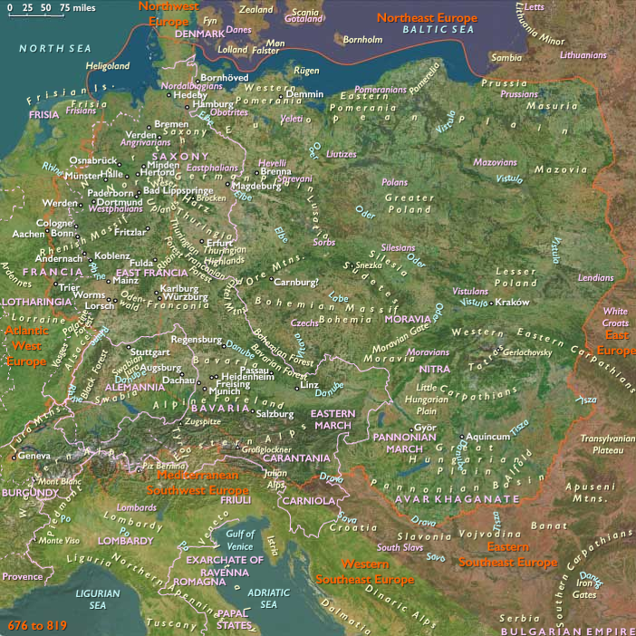
At the center of the continent, Central Europe bridged the Mediterranean, the North Sea, and the Eurasian steppe.
Its three natural components—the eastern plains of the Danube and Vistula, the southern Alpine corridors of Raetia and Noricum, and the western Rhineland frontier—were never ruled as one but developed in tandem, linked by rivers, roads, and migration.
Over nearly two millennia, Celts, Romans, Sarmatians, Germans, and Slavs each left their imprint. The region’s history from the Iron Age through late Antiquity was one of integration through diversity: from tribal oppida to Roman provinces and, after Rome’s fall, to the Carolingian empire that reclaimed its center.
Geography and Environment
The region’s unity lay in its waterways and passes.
-
In the east, the Danube, Elbe, and Vistula threaded loess plains and forested uplands through present-day Poland, Hungary, and Bohemia, their fertile valleys sustaining dense settlement.
-
The south consisted of the Alpine and sub-Alpine basins—Tyrol, Carinthia, and the Swiss Plateau—where copper, salt, and Alpine pastures underwrote a transhumant economy.
-
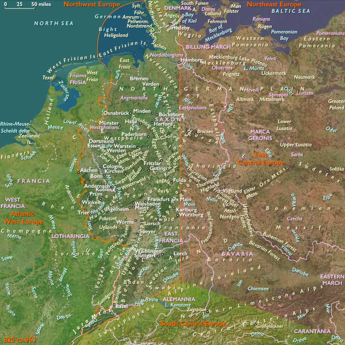
The west, anchored on the Rhine corridor, combined temperate agriculture with riverine trade, opening north to the North Sea and south to Gaul and the Mediterranean.
Climatic oscillations—the Late Bronze Age cool phase, the Roman Warm Period, and the fluctuations of late Antiquity—alternately favored expansion and contraction of settlement, but the region’s ecological diversity provided stability through change.
Societies and Political Developments
Celtic Foundations and Roman Conquest
From the 8th to 1st centuries BCE, Hallstatt and La Tène cultures dominated the uplands and river valleys. Celtic oppida such as the Heuneburg, Manching, and Bratislava were proto-urban centers with metallurgy, coinage, and long-distance trade.
To the east, Dacians and Thracians built fortified hilltop towns, while steppe peoples—Scythians and Sarmatians—pressed in from the Pontic frontier.
Roman expansion from the 1st century BCE onward transformed these worlds.
The provinces of Raetia, Noricum, Pannonia, and Germania Superior laced the region with roads, bridges, and legionary colonies: Vindobona (Vienna), Carnuntum, Augsburg, Cologne, Mainz, and Trier.
Latin law, architecture, and Christianity spread along the Rhine–Danube axis, binding Alpine valleys to Mediterranean markets.
Barbarian Migrations and Successor Realms
From the 2nd to 6th centuries CE, the Germanic migrations (Goths, Vandals, Lombards) and steppe incursions (Huns, later Avars) reconfigured the map.
While Dacia north of the Danube was abandoned, Romanized populations endured in the Alpine and Rhineland provinces.
In the Carpathian Basin, Avars forged a nomadic empire (6th–8th c.); to the north, Slavic peoples spread through Poland, Bohemia, and the upper Elbe, adapting shifting cultivation to forest soils.
By the 8th–9th centuries, Bavarian, Alemannic, and Frankish duchies consolidated the west and south, while Carantania and early Moravian and Polish formations took shape in the east.
The Carolingian Heartland
In the west, the Franks turned the old Roman frontier into the nucleus of renewal.
From Trier and Cologne to Aachen, the Rhine valley became the core of Merovingian, then Carolingian, power.
Charlemagne’s coronation in 800 CE crowned three centuries of recovery, drawing on Roman roads, monastic estates, and the agrarian surplus of the Rhineland and Alpine forelands.
Economy and Exchange
Agriculture expanded from Iron Age clearings to Roman villa estates and Carolingian manors.
The iron plow, crop rotation, and horse harness improved yields; vines and orchards lined the Rhine and Danube.
Mining of salt, copper, and iron in Alpine zones supplied tools and weapons; the Amber Route, Danube, and Rhine carried metals, wine, and ceramics across the region.
After Rome’s decline, trade contracted but never ceased: episcopal towns and abbeys kept the market network alive until Carolingian revival restored continental exchange.
Technology and Material Culture
Technological continuity marked the region’s strength.
Hallstatt ironworking laid foundations for Roman metallurgy; Roman engineering—roads, aqueducts, mills—remained visible for centuries.
Alpine communities perfected terracing, transhumant dairying, and bridge building over torrents.
Post-Roman craftsmen fused Germanic and Roman styles: brooches and weapon fittings of cloisonné gold, timber-rampart hillforts, and early Christian basilicas in stone.
Belief and Symbolism
Religious change paralleled political transformation.
Celtic polytheism and Dacian mountain cults yielded to Roman civic gods, then to Christianity.
By the 4th century CE, bishoprics dotted the Rhine and Danube; saints’ cults (e.g., Martin of Tours, Severin of Noricum) replaced heroic warrior deities.
In pagan enclaves, Slavic and Germanic animisms persisted into the 8th–9th centuries, even as monasteries at Reichenau, Fulda, and St. Gallen disseminated the new faith and literacy.
Adaptation and Resilience
Central Europe’s endurance rested on layered infrastructures:
-
River networks provided mobility when frontiers collapsed.
-
Alpine passes (Brenner, Great St. Bernard, Gotthard) guaranteed transcontinental trade.
-
Agrarian diversity—from steppe pastures to vineyard slopes—hedged climatic and political risk.
Roman urban shells became episcopal towns; hillforts evolved into medieval castles.
Even under invasion, the region’s ecological and cultural web proved self-repairing.
Regional Synthesis and Long-Term Significance
By 819 CE, Central Europe had completed its transformation from an Iron-Age mosaic to the heartland of medieval Christendom.
The east, heir to Celtic, Dacian, and steppe legacies, blended into the Slavic and Avar worlds that would birth Moravia, Poland, and Hungary.
The south, keeper of the Alpine passes, preserved Roman engineering and Latin speech, incubating the Rhaeto-Romance and Bavarian spheres.
The west, rejuvenated under the Franks, became the imperial and ecclesiastical core of the Carolingian world.
Together these three subregions—eastern plains, southern Alps, and western Rhine—formed a single organism whose arteries were rivers and passes.
Their natural division explains the region’s balance: eastward the open steppe, southward the mountain corridors, westward the frontier heart.
From this equilibrium emerged Europe’s enduring center—where empires met, cultures fused, and the medieval order first took shape.
Groups
Topics
Commodities
Subjects
Regions