Southeast Asia (1684–1827 CE) Monsoons, Mandalas, and…
1684 CE to 1827 CE
Southeast Asia (1684–1827 CE)
Monsoons, Mandalas, and Maritime Corridors of Empire
Geography & Environmental Context
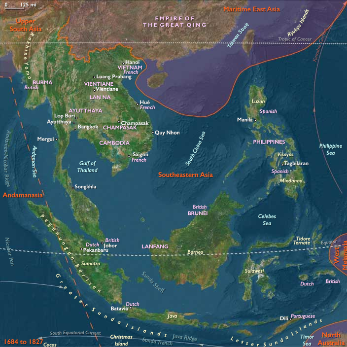
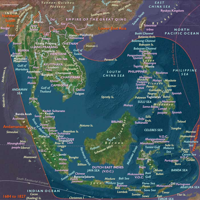
Southeast Asia—stretching from Myanmar and Vietnam to Sumatra, Java, Borneo, Sulawesi, the Philippines, and the Andaman–Nicobar arc—formed one of the most intricate mosaics of land and sea on Earth. Its centers of gravity were both continental and insular: the rice deltas of the Irrawaddy, Chao Phraya, and Mekong sustained great inland capitals such as Ayutthaya, Ava, and Hue, while the maritime straits and archipelagos—Malacca, Makassar, Manila, and Aceh—bound the Indian Ocean to the South China Sea. Peripheral chains like Simeulue, Nias, Mentawai, and the Andaman and Nicobar Islands linked the region to the Bay of Bengal and Indian Ocean worlds.
Climate & Environmental Shifts
The tropical monsoon remained the rhythm of both agriculture and commerce: rains refilled paddies from May to October and withdrew to reveal dry-season trading lanes. Yet the Little Ice Age brought irregular droughts, cool seasons, and the most volatile century of storms in living memory. El Niño–Southern Oscillation pulses caused crop failures and famines in Vietnam and the Philippines; cyclones and typhoons wrecked fleets from Arakan to Luzon. Volcanic eruptions, particularly on Java, devastated harvests but renewed soils. In the Andaman and Nicobar arc, recurrent earthquakes and tsunamis reshaped coasts and reinforced oral traditions like the smong of Simeulue—an enduring memory of survival.
Subsistence & Settlement
Agriculture and maritime trade intertwined across the region’s peninsulas and islands:
-
Mainland rice kingdoms: Irrigated deltas and terraced valleys in Burma, Siam, Cambodia, Laos, and Vietnam produced surpluses that sustained vast courts and temple complexes.
-
Island agriculture and spice cultivation: Java, Sumatra, and Borneo combined rice with pepper, coffee, and sugar; the Moluccas specialized in cloves and nutmeg; the Malay Peninsula mined tin.
-
Outer island and coastal economies: In Aceh, pepper plantations financed sultanates; in the Mentawai and Nias Islands, swidden gardens and fishing anchored self-sufficient villages.
-
Andaman and Nicobar communities: Practiced mixed subsistence—reef fishing, coconut groves, and forest foraging—rooted in ritual and kinship.
-
Philippine and Sulawesi hinterlands: Blended rice terraces with coconuts, bananas, and maize, sustaining both lowland and upland communities under Spanish and local authority.
The resulting human geography was polycentric: riverine capitals, port cities, and island chiefdoms coexisted, bound by seasonal trade and tribute.
Technology & Material Culture
-
Agrarian mastery: Irrigation canals, buffalo plows, and flood-retaining embankments underpinned rice civilization.
-
Maritime technologies: Praus, junks, lanong warships, and European East Indiamen traversed the straits; shipyards in Sulawesi, Borneo, and Luzon produced fleets for both trade and war.
-
Artisanal production: Batik and ikat weaving, bronze casting, ceramics, and fine woodworking thrived in guilds and royal workshops.
-
Architecture: Tiered pagodas, gilded temples, wooden palaces, coral mosques, and Baroque churches marked religious pluralism.
-
European military infrastructure: Fortified outposts—Batavia, Malacca, Penang, and Manila—blended Asian design with bastioned masonry and imported artillery.
Movement & Interaction Corridors
Southeastern Asia was the maritime heart of the early modern world:
-
Oceanic arteries: The Straits of Malacca and Sunda carried Asian, Arab, and European ships; spices, silks, silver, and slaves moved through their narrows.
-
Overland corridors: Caravans from Yunnan linked the mainland uplands to the Gulf of Tonkin and the Mekong; teak and tin from the mountains met Chinese and Indian merchants at port.
-
Global circuits: The Manila Galleon route (1565–1815) brought Mexican silver; VOC ships from Batavia monopolized spice flows; EIC outposts in Sumatra, Penang, and Singapore (from 1819) reshaped maritime geographies.
-
Island connectors: The Aceh–Nias–Mentawai chain and the Andaman–Nicobar corridor served as stepping-stones between Bay of Bengal routes and the eastern archipelago.
-
Religious and intellectual flows: Pilgrimages, Sufi networks, and Buddhist monastic circuits linked Mandalay, Ayutthaya, Aceh, and Malacca, paralleling European missionary and mercantile paths.
Cultural & Symbolic Expressions
The region’s cultural landscape was among the richest in the world:
-
Religion and cosmology: Theravada Buddhism flourished in mainland courts; Islam guided sultanates across the archipelago; Catholicism transformed Filipino society; Hindu and animist legacies persisted in ritual and art.
-
Courtly synthesis: Ayutthaya, Hue, and Bangkok patronized mural painting, chronicles, and dance-dramas. In Java, wayang kulit shadow theater reinterpreted epics within an Islamic frame.
-
Local ritual life: In the Andaman and Nicobar Islands, forest and sea spirits governed conduct; in Nias and Simeulue, ancestor stones and feasting cycles maintained social order.
-
Music and performance: The gamelan of Java, kulintang of the Philippines, and ronggeng dances of the Malay world reflected shared rhythmic aesthetics shaped by trade, faith, and memory.
-
Diasporic creativity: Chinese guilds, Indian traders, and Arab scholars established cultural enclaves in ports, blending cuisines, crafts, and languages into a syncretic urban heritage.
Environmental Adaptation & Resilience
Communities across Southeastern Asia harnessed diversity to endure volatility:
-
Agrarian systems combined rice, maize, taro, and yams to hedge climate risk.
-
Maritime economies shifted trade allegiance between Dutch, English, Portuguese, and Chinese markets to avoid monopolies.
-
Urban recovery: Timber rebuilding and canal dredging after floods or eruptions allowed rapid restoration of trade.
-
Social safety nets: Monasteries, mosques, and parishes redistributed food and aid during crises.
-
Island adaptation: In the outer arc—Simeulue, Nias, Mentawai, Andamans, Nicobars—mobility, oral memory, and diversification of fishing and forest resources ensured survival after storms or earthquakes.
Political & Military Shocks
The eighteenth and early nineteenth centuries brought reconfiguration across land and sea:
-
Mainland upheavals: The fall of Ayutthaya (1767) and rise of Bangkok under the Chakri dynasty; the Tây Sơn revolutions in Vietnam (1770s–1802) leading to Nguyễn unification; and the First Anglo-Burmese War(1824–26) marking Britain’s encroachment.
-
Maritime rivalries: The VOC consolidated its spice monopoly in the Moluccas and Java; Aceh declined as Dutch and English diverted trade to Malacca and Penang.
-
New colonial footholds: The EIC established Penang (1786) and Singapore (1819), redrawing the map of the Straits.
-
Local resistance and piracy: Sulu and Iranun fleets dominated raiding and commerce in the Sulu–Celebes seas; Andamanese communities fiercely repelled missionary or trading incursions.
-
Andamanasia’s transition: Danish and Austrian attempts to colonize the Nicobars failed; Aceh fragmented into rival chiefdoms; by the 1820s, the Cocos Islands entered British navigational circuits.
Transition
Between 1684 and 1827 CE, Southeastern Asia balanced between autonomous mandalas of power and colonial corridors of empire. Agrarian kingdoms and port polities maintained intricate balances of trade, faith, and diplomacy under the monsoon’s rhythm. European companies imposed monopolies but depended on indigenous pilots, merchants, and farmers.
By the early nineteenth century, Bangkok, Hue, and Manila anchored enduring state systems, while the Dutch, British, and Spanish tightened their grip on the seas. Yet from Aceh’s mosques and Java’s paddies to Nias’s megaliths and Ayutthaya’s stupas, a deeply rooted regional order persisted—adaptable, polycentric, and resilient, steering its own course through the gathering tides of empire.
Groups
Topics
Commodities
Subjects
Regions