The Middle East (1396–1539 CE) Timurid Shock,…
1396 CE to 1539 CE
The Middle East (1396–1539 CE)
Timurid Shock, Turkoman Interlude, and the Ottoman–Safavid Divide
Geographic & Environmental Context
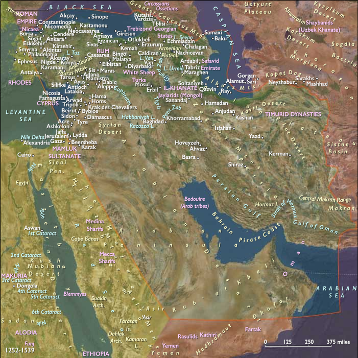
The Middle East in this era formed the inland hinge between Anatolia, Mesopotamia, western Iran, and the Caucasian margins, a region of upland barriers, river plains, caravan basins, and dry plateaus. Its major environmental anchors included the Tigris–Euphrates basin, the Iranian plateau and its western approaches, the Zagros highlands, and the northern corridors leading toward Anatolia and the Caucasus. Across this terrain, irrigated belts, rain-fed plains, and pastoral uplands overlapped uneasily, making the region at once productive and vulnerable. It was a land where imperial projects depended on controlling both water and movement, yet where neither could ever be fully stabilized. Your broader regional notes are especially useful here in emphasizing the interplay of rivers, plateaus, caravan routes, and imperial capitals across the larger Near and Middle East world.
Climate & Environmental Shifts
The Little Ice Age sharpened environmental instability. In Mesopotamia, river fluctuations altered irrigation patterns and could turn prosperity into scarcity within a few seasons. On the Iranian plateau, recurrent drought strained qanats, reduced yields, and intensified pressure on pastoral mobility. Highland snowmelt fed rivers and orchards in some years, but could also trigger destructive floods. These shifts did not erase settled life; rather, they made survival depend on flexibility. Productive zones endured, but often as fragile islands of control within larger belts of uncertainty.
Subsistence & Settlement
The region’s economy depended on layered land use, not a single dominant pattern. In the riverine and lowland zones, farmers cultivated wheat, barley, cotton, and rice, while orchards and gardens flourished where irrigation could be maintained. On drier ground, cultivation became intermittent and vulnerable, often blending into pastoral use. Turkoman, Kurdish, Arab, and Lur herders moved flocks seasonally across plateaus and mountain margins, buffering climatic shocks through mobility. Settlements ranged from major cities such as Baghdad, Tabriz, and later Safavid Tabriz and Ottoman-held Iraqi centers, to smaller caravan and agricultural nodes whose fortunes rose and fell with irrigation, taxation, and war. Villages and towns often persisted not because conditions were stable, but because communities repeatedly rebuilt amid political upheaval.
Technology & Material Culture
Agrarian life relied on qanats, canals, flood-control works, terrace systems, norias, and wells, all of which required continuous maintenance. Where these systems failed, cultivation retreated quickly. Metal tools, plows, and local hydraulic devices supported agriculture, but political fragmentation often made upkeep uncertain. Meanwhile, the region remained a major center of Persianate textile production, carpet weaving, manuscript arts, ceramics, and metalwork. Architecturally, the era saw the continued prestige of Timurid domes, tilework, and madrasas, followed by evolving Safavid and Ottoman forms. Even amid war, cities such as Herat, Tabriz, and Baghdad remained cultural magnets. Material culture was therefore not a sign of peace so much as proof of the region’s ability to generate refinement under pressure.
Movement & Interaction Corridors
The Middle East was defined by movement, even when that movement left no permanent roads on the land. Caravan routes linked Tabriz, Baghdad, Anatolia, the Caucasus, and the Iranian interior; river transport connected portions of Mesopotamia; and long-distance exchanges tied the region to Black Sea, Mediterranean, and Gulf networks. Pilgrimage, trade, scholarship, and war all moved through the same broad corridors. Yet these were not fixed systems in the modern sense. Routes shifted with drought, taxation, raiding, and imperial control. What endured was not a stable map of roads, but a persistent logic of circulation. The region’s coherence rested less on unity than on corridor density across imperial borders.
Cultural & Symbolic Expressions
This was one of the great Persianate and Islamic cultural zones of the age. The Timurid legacy radiated outward through literature, architecture, urban culture, and courtly patronage. Sufi traditions and scholarly networks linked city and countryside, often crossing dynastic and sectarian lines. The era also witnessed a growing Shiʿi transformation under the Safavids, who used shrines, ritual, and patronage to reshape political identity. At the same time, Ottoman expansion carried a more assertive Sunni imperial orthodoxy eastward. The result was not mere religious difference, but a new symbolic geography, in which doctrine, dynasty, and territory increasingly reinforced one another. In the Caucasian margins, older Christian traditions endured amid imperial rivalry, while Armenian and Georgian communities continued to act as intermediaries between worlds.
Environmental Adaptation & Resilience
Survival depended on managing instability rather than eliminating it. Irrigation communities maintained qanats and canals collectively; herders altered routes to preserve flocks during drought or heavy winter loss; orchards, date palms, and vineyards provided long-term stability where annual grains were risky. Cities relied on imported food and caravan supply systems. Rural communities frequently shifted between cultivation and pastoralism depending on tax burdens, raiding, and rainfall. In this sense, resilience in the Middle East came not from fixed order, but from adaptive overlap: agricultural, pastoral, urban, and mercantile systems coexisted because none could safely stand alone.
Technology & Power Shifts (Conflict Dynamics)
The period opened beneath Timur’s shadow. Between the late fourteenth century and the early fifteenth, his invasions devastated Syria, Iraq, and parts of western Iran, sacking cities such as Damascus and Baghdad and weakening older dynasties. His defeat of Bayezid I at Ankara in 1402 temporarily shattered Ottoman authority and deepened fragmentation across Anatolia and adjoining regions. In the aftermath, the Jalayrids declined, while the Kara Koyunlu under Qara Yusuf rose to dominate Mesopotamia and western Persia, especially after consolidating control over Baghdad.
Following Qara Yusuf’s death in 1420, internal conflict weakened Kara Koyunlu stability, though Jahan Shah later restored cohesion and fostered a notable period of cultural patronage centered on Tabriz. Meanwhile, the Timurids under Shah Rukh preserved stronger authority farther east, turning Herat into a major center of Persianate culture even as western Timurid influence receded.
By the mid-fifteenth century, the Ottoman state recovered under Murad II, then expanded forcefully under Mehmed II. Yet in the Middle East proper, the decisive political shift came with the rise of the Aq Qoyunlu under Uzun Hasan, who defeated and killed Jahan Shah in 1468, displacing Kara Koyunlu dominance across much of western Iran and Iraq. Ottoman defeat of Aq Qoyunlu forces later in the 1470s curtailed their western ambitions, but did not restore stable regional unity.
The true turning point came with the Safavid revolution. Under Ismail I, the Safavids overthrew the last Aq Qoyunlu remnants and in 1501 established a new empire centered on Tabriz, declaring Twelver Shiʿism the state religion. This transformed the region’s political and confessional map. The Safavid capture of Baghdad in 1508 extended this revolution into Mesopotamia. Ottoman alarm intensified, especially as Qizilbash influence spread among Turkmen populations in eastern Anatolia. Under Selim I, the Ottoman Empire responded militarily, defeating the Safavids at Chaldiran in 1514, a battle that fixed firearms and artillery as decisive instruments of imperial power and helped define the frontier between the two empires.
The next great transformation came with Ottoman victories over the Mamluks at Marj Dabiq (1516) and the conquest of Cairo (1517). Though these campaigns primarily absorbed Syria and Egypt, their effects reshaped the Middle East by redirecting trade, enlarging Ottoman prestige, and bringing the Sunni holy cities under Ottoman protection. Under Suleiman I, Ottoman power pressed farther into Iraq; by 1534, Ottoman forces annexed Baghdad, establishing a new balance with the Safavids. From that point onward, the Middle East was increasingly defined by the Ottoman–Safavid divide, with Iraq and the western Iranian frontier becoming enduring zones of contest.
Transition (to 1539 CE)
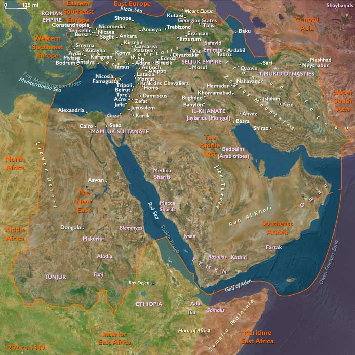
By 1539, the Middle East had been fundamentally reordered. The old landscape of post-Mongol successor states, Timurid shock, and Turkoman confederations had given way to a harder imperial duality. The Ottoman Empire now held Iraq’s principal urban centers and projected Sunni authority across the western half of the region, while the Safavid Empire anchored a newly consolidated Shiʿi Iran to the east. Between them stretched not a fixed border so much as a zone of pressure: caravan cities, irrigation plains, upland marches, and contested loyalties.
The result was a Middle East no longer defined primarily by collapse, but by partitioned consolidation. Water, pasture, city, and caravan still bound the region together, yet every one of those systems now operated beneath the shadow of two rival imperial projects. By the late 1530s, the land between the Tigris, the Zagros, and the routes leading toward Anatolia and the Caucasus had become one of the central fault lines of the early modern Islamic world.
People
Groups
Topics
Commodities
Subjects
Regions
The Near and Middle East
View →Subregions