Northwest Europe (909 BCE–819 CE): Atlantic Landscapes,…
909 BCE to 819 CE
Northwest Europe (909 BCE–819 CE): Atlantic Landscapes, Maritime Networks, and the Formation of Regional Kingdoms
Geographic and Environmental Framework
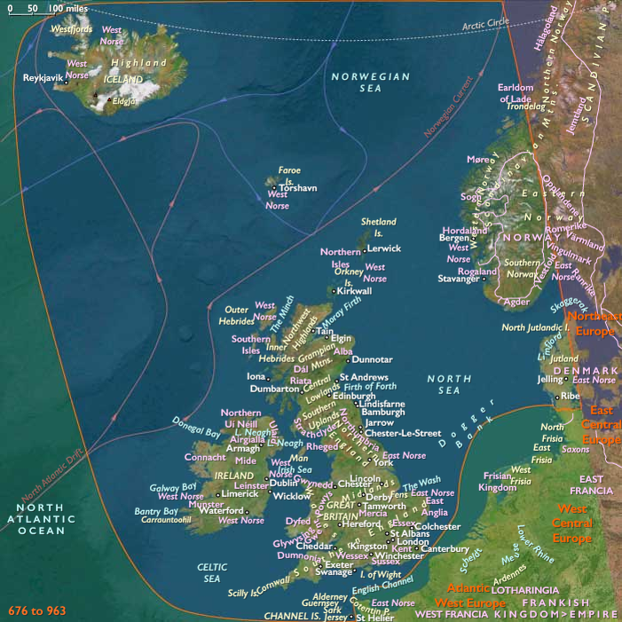
Northwest Europe comprises Ireland, Great Britain, the Channel Islands, western Denmark, western Norway, Iceland, the Faroe Islands, Orkney, Shetland, and the surrounding smaller archipelagos. The subregion is shaped by the North Atlantic Ocean, the North Sea, the Irish Sea, the English Channel, and the Norwegian coastal corridor. Rugged headlands, fjords, sea lochs, estuaries, tidal flats, offshore islands, upland plateaus, peatlands, river valleys, and pockets of fertile lowland created sharply contrasting environments within a closely connected maritime world.
The Atlantic climate brought comparatively mild winters, cool summers, frequent rainfall, strong winds, and recurrent storms. Oceanic conditions supported temperate woodland, heath, rough pasture, wetlands, and productive estuarine ecosystems, but they also shortened growing seasons in northern and upland districts. Agricultural opportunity was greatest in southern and eastern Britain, eastern Ireland, lowland Scotland, western Denmark, and the more sheltered valleys of western Norway. Elsewhere, communities depended more heavily on livestock, fishing, gathering, seasonal movement, and maritime exchange.
These environmental contrasts did not isolate the subregion. Rivers, estuaries, straits, fjords, and island chains formed an interconnected transportation system. Sea travel was often easier than overland movement, allowing communities separated by mountains or moorlands to remain linked through coastal navigation.
Iron Age Landscapes and Regional Adaptation
At the beginning of the period, communities across Britain, Ireland, western Scandinavia, and the northern archipelagos were adapting to the widespread use of iron. Iron tools gradually improved woodland clearance, cultivation, carpentry, boatbuilding, and craft production, although older bronze technologies remained important for ornament and prestige display.
Settlement patterns varied according to local ecology. Enclosed farmsteads, roundhouse communities, upland compounds, lake settlements, hillforts, and dispersed coastal villages emerged within landscapes already shaped by long histories of cultivation and grazing. In fertile lowlands, cereal agriculture expanded alongside cattle, sheep, and pig husbandry. In Atlantic and northern districts, mixed pastoralism, shellfish gathering, inshore fishing, seabird exploitation, and seasonal use of islands and uplands remained essential.
Hillforts became especially prominent in parts of southern and western Britain, but they did not constitute a uniform political system. Some served as defended settlements, seasonal gathering places, storage centers, craft locations, or markers of territorial authority. Many communities continued to live in smaller farmsteads beyond their walls. In Ireland, Scotland, western Britain, Orkney, Shetland, Denmark, and Norway, political organization remained distributed among kin groups, local leaders, and shifting regional alliances.
Agriculture, Pastoralism, and Managed Ecologies
Agriculture was never uniform across Northwest Europe. Communities selected crops and livestock according to rainfall, soils, elevation, and exposure. Barley, wheat, oats, flax, and other crops were cultivated where conditions permitted, while cattle and sheep became increasingly important in wetter and cooler areas. Pigs remained closely associated with woodland and settlement margins.
Fields, grazing grounds, woodlands, marshes, and uplands were managed as connected systems. Woodland clearance created pasture and arable land, but forests continued to supply fuel, timber, pannage, forage, and raw materials. Heathlands and moors were maintained through grazing and burning. Peatlands expanded in some districts as a result of climatic conditions, soil exhaustion, and long-term land use, constraining agriculture while preserving routes, artifacts, and human remains.
In western Norway and the northern islands, small cultivated plots were integrated with extensive grazing, fishing, and seaborne exchange. In western Denmark, richer lowlands supported more concentrated agriculture and livestock production. Across Ireland and Britain, regional specialization developed without eliminating household-level subsistence.
Maritime Economies and North Sea Connectivity
The coast was the principal connective tissue of the subregion. Communities exploited estuaries, sheltered bays, tidal inlets, fjords, and offshore fishing grounds. Boats transported people, livestock, stone, timber, metals, foodstuffs, and prestige goods between islands and mainland coasts.
North Sea and Channel routes connected Britain and western Denmark to Gaul, the Rhine basin, and the Baltic approaches. Atlantic routes linked Ireland, western Britain, Brittany, Iberia, and the northern archipelagos. Western Norway formed a long maritime corridor in which coastal communities could move between fjords, islands, and seasonal resource zones.
Trade rarely depended upon large permanent ports during the earlier centuries. Exchange was conducted through river mouths, beach landings, seasonal gathering places, elite compounds, and coastal settlements. Tin, iron, salt, quernstones, hides, wool, livestock, amber, glass, pottery, ornaments, and enslaved people moved through overlapping regional networks. The volume and direction of trade changed repeatedly, but maritime interaction remained a durable feature of Northwest European life.
Political Authority and Iron Age Regionalization
Political power emerged from control over land, livestock, labor, craft production, exchange, and ritual authority. Leadership was generally local and negotiated rather than bureaucratic. Some chiefs or elite households accumulated imported goods, weapons, livestock, and followers, but political landscapes remained fragmented.
Continental artistic and technological traditions influenced Britain and western Denmark without producing a single unified “Celtic” society. Communities selectively adopted Hallstatt and later La Tène styles while preserving local languages, settlement systems, and ritual practices. Population movement occurred, but much cultural change resulted from exchange, imitation, intermarriage, and elite competition.
By the later Iron Age, some parts of southern Britain developed larger settlement complexes and more concentrated political territories. Oppida, coinage, imported wine, and specialized production appeared in areas with particularly strong continental connections. Ireland, northern Britain, western Norway, and the island zones followed different trajectories, maintaining smaller-scale and more dispersed systems of authority.
Roman Conquest and the Reorganization of Britain
Roman intervention transformed southern Britain after the invasion of 43 CE. The province of Roman Britain became integrated into the administrative, military, and commercial systems of the Roman Empire. Roads, forts, towns, military supply networks, mines, villas, and estate agriculture reorganized parts of the landscape.
Londinium, Eboracum, Camulodunum, and other urban centers became nodes of taxation, trade, government, and craft production. Military frontiers, especially Hadrian’s Wall and its associated forts, concentrated people and resources along the northern boundary. Rural settlements supplied grain, livestock, timber, minerals, and manufactured goods to towns and garrisons.
Roman rule remained geographically uneven. Wales, northern Britain, and upland districts were incorporated primarily through military occupation and regional administration rather than dense urbanization. Ireland, western Norway, western Denmark, Iceland, and the northern Atlantic islands remained outside imperial control. Nevertheless, Roman goods, coins, technologies, and diplomatic contacts circulated beyond the formal frontier.
Romanization did not erase local traditions. Indigenous communities adapted Roman institutions, material culture, and religious practices to established social systems. Villas and towns coexisted with roundhouses, farmsteads, native settlements, local shrines, and regional identities.
Religious Change and Cultural Synthesis
Religious life throughout the epoch was diverse and locally rooted. Iron Age communities deposited objects in rivers, bogs, lakes, caves, boundaries, and settlement spaces. Sacred groves, ancestral places, springs, hilltops, and long-abandoned monuments retained significance. Bog bodies and ritual deposits in Denmark and Britain reveal ceremonial practices embedded in wetland landscapes.
Under Roman rule, local deities were associated with Roman gods, producing hybrid religious traditions. Temples, household shrines, military cults, and sacred waters became part of a plural religious landscape. Christianity appeared gradually in Roman Britain, particularly among some urban, military, and elite communities, but remained one tradition among many until Late Antiquity.
After Roman government weakened, Christianity expanded through different regional networks. In Ireland and western Britain, ecclesiastical communities developed through local patronage rather than direct imperial administration. Missions associated with Palladius, Patrick, Columba, Augustine, Aidan, and others became part of a broader process in which royal households, monasteries, local churches, and missionary communities reshaped religious life.
Christian conversion was neither immediate nor uniform. Older sacred places, seasonal customs, burial practices, and regional traditions persisted or were reinterpreted within Christian frameworks. In western Scandinavia, pre-Christian beliefs remained dominant through most of the period, though trade and diplomatic contacts increasingly exposed coastal communities to Christianity.
The End of Roman Rule and Regional Fragmentation
During the fourth and early fifth centuries, Roman Britain experienced military strain, political instability, declining state expenditure, and the weakening of long-distance administrative systems. Towns contracted, coin circulation diminished, and some villas and forts were abandoned or repurposed. Rural production continued, but it became increasingly organized through local and regional networks.
The end of Roman government did not produce a single uniform collapse. Some communities preserved elements of Roman law, Christianity, literacy, architecture, and estate organization. Elsewhere, settlement shifted toward smaller farmsteads, defended compounds, reused forts, and local centers.
New political formations emerged across Britain. Germanic-speaking settlers from the North Sea coast established communities in eastern and southern Britain, while Brittonic-speaking polities persisted in Wales, Cornwall, northern England, and southern Scotland. Dál Riata, Gwynedd, Strathclyde, Rheged, Dumnonia, and other kingdoms developed within older regional landscapes. In eastern Britain, the foundations of Kent, Wessex, Mercia, Northumbria, East Anglia, and other Anglo-Saxon kingdoms gradually took shape.
These political changes were closely connected to migration, warfare, marriage, landholding, tribute, and control of coastal and river corridors. They did not erase older populations or create sharply bounded ethnic territories. Cultural identities remained fluid and locally negotiated.
Ireland and the Irish Sea World
Ireland remained outside Roman conquest but was closely connected to Britain and continental Europe. Cattle pastoralism, mixed farming, craft production, river travel, and coastal exchange supported numerous local kingdoms. Political authority rested with dynasties, client networks, learned specialists, and legal traditions rather than centralized territorial states.
The Irish Sea served as a zone of movement rather than a boundary. Communities in Ireland, western Britain, the Isle of Man, and western Scotland exchanged people, goods, religious ideas, and artistic traditions. Irish-speaking settlers established enduring communities in western Scotland, contributing to the growth of Dál Riata.
Monastic foundations became important centers of worship, education, manuscript production, metalworking, farming, and hospitality. They were not isolated from surrounding society. Monasteries depended upon landed estates, patronage, tenant communities, fisheries, livestock, workshops, river crossings, and coastal landings. Their influence spread through networks of affiliated churches and dependent settlements.
Kingdoms, Monasteries, and Distributed Institutions
Between the sixth and eighth centuries, political authority became more clearly territorial in Britain and Ireland, though it remained divided among many competing kingdoms. Kingship rested upon military followings, tribute, agricultural surplus, gift exchange, dynastic marriage, and religious patronage.
Monasteries and churches became embedded within these political and economic systems. Iona, Lindisfarne, Wearmouth–Jarrow, Kells, Armagh, and numerous smaller foundations acted as regional institutions, but the Christian landscape remained dispersed. Parish organization was incomplete, and many religious communities consisted of modest compounds surrounded by fields, pasture, workshops, dependent farms, and landing places.
Scholarship developed within this distributed institutional landscape. Latin learning, biblical commentary, computus, law, history, poetry, and manuscript illumination flourished in several centers. Figures such as Bede emerged from networks sustained by agricultural estates, maritime communication, and royal protection. Insular artistic traditions blended local metalworking, manuscript design, Christian symbolism, and influences transmitted from the Mediterranean and continental Europe.
Western Scandinavia and the Emergence of Viking-Age Systems
Western Denmark and western Norway remained politically fragmented through much of the epoch. Coastal communities were organized around farmsteads, local assemblies, chieftains, seasonal gatherings, and maritime exchange. Agriculture, cattle raising, fishing, hunting, iron production, and shipbuilding supported increasingly complex regional societies.
Long, deeply indented coasts encouraged the development of sophisticated maritime knowledge. Clinker-built vessels evolved over centuries from smaller coastal craft into larger ships capable of carrying crews, cargo, livestock, and weapons across open water. Navigation depended upon accumulated familiarity with currents, weather, landmarks, islands, and seasonal conditions rather than formal charts.
By the eighth century, some Scandinavian rulers were consolidating control over maritime corridors, tribute networks, trading settlements, and strategic defenses. Hedeby and the Danevirke reflected growing political and commercial organization in the Danish borderlands. Western Norwegian coastal communities participated in expanding networks reaching the British Isles, the North Sea, and the North Atlantic.
The raids that became visible in written sources after the attack on Lindisfarne in 793 emerged from these longer developments. They were not a sudden departure from isolation but an intensification of existing seafaring, trade, warfare, migration, and elite competition.
North Atlantic Expansion
Orkney and Shetland formed long-standing maritime societies closely connected to northern Scotland and the North Sea. Their populations practiced mixed farming, fishing, craft production, and seasonal movement across island landscapes. By the late eighth and early ninth centuries, Scandinavian contact was increasing, though the pace and character of Norse settlement varied between islands and remains difficult to reconstruct precisely.
The Faroe Islands and Iceland lay beyond the principal settled zone for most of the epoch. Evidence for pre-Norse human presence in the Faroes is possible but remains debated, while Iceland appears to have lacked permanent settlement before the later ninth century. Traditions of Irish ecclesiastical voyagers may preserve memories of temporary Atlantic journeys, but they do not establish extensive colonization before 819.
These northern islands nevertheless formed part of the expanding geographical horizon of Northwest European seafarers. Improvements in shipbuilding and navigation were gradually transforming the open Atlantic from a barrier into a traversable, though still dangerous, maritime environment.
Economic Resilience and Regional Exchange
Economic systems remained diverse throughout the epoch. Roman Britain possessed towns, roads, taxation, military supply chains, large estates, and specialized industries. Post-Roman societies relied more heavily on local agricultural production, tribute, household crafts, seasonal markets, coastal exchange, and ecclesiastical estates. Ireland and western Scandinavia maintained their own regional economies while participating in broader maritime networks.
Salted and dried fish, wool, hides, livestock, grain, iron, timber, quernstones, ornaments, glass, wine, pottery, and enslaved captives moved between regions. Exchange linked peasant households, chieftains, monasteries, royal courts, merchants, sailors, and craft specialists. Rivers and coasts remained more important than formal roads in many districts.
Communities responded to climatic fluctuation, storm damage, crop failure, warfare, and political disruption through mixed subsistence systems. Households combined farming with herding, fishing, woodland use, craftwork, and seasonal mobility. This ecological flexibility underpinned the persistence of settlement across exposed coasts, islands, uplands, and northern maritime environments.
Political Consolidation and the Approach of the Viking Age
By the eighth and early ninth centuries, several Anglo-Saxon kingdoms had developed substantial administrative and military capacity. Northumbria became a major political and scholarly center before internal conflict weakened it. Mercia expanded under rulers such as Æthelbald and Offa, using tribute, fortified boundaries, religious patronage, and control of trade to extend its influence. Wessex was beginning the rise that would make it increasingly powerful in the ninth century.
In Wales, Cornwall, northern Britain, and Ireland, numerous regional kingdoms preserved distinct political traditions. Pictish rulers dominated much of northern and eastern Scotland, while Gaelic influence continued to develop in the west. Irish kings competed for regional supremacy through warfare, alliance, patronage, and claims to ritual precedence, but no single ruler exercised permanent control over the island.
Political systems were becoming more ambitious, yet they remained dependent upon environmental and economic foundations: productive lowlands, cattle wealth, river valleys, coastal routes, fisheries, estate agriculture, and maritime transport. Even the strongest kingdoms were constrained by terrain, seasonality, communications, and the enduring fragmentation of the Atlantic landscape.
Legacy of the Age
By 819 CE, Northwest Europe had been transformed from a mosaic of Iron Age farming and maritime communities into an interconnected landscape of kingdoms, monasteries, trading centers, agricultural estates, fortified frontiers, and expanding sea routes. Roman conquest had reorganized much of Britain without absorbing Ireland or western Scandinavia. The end of Roman rule produced regional fragmentation, migration, and new political identities rather than a simple return to isolation.
Christianity became deeply rooted in Britain and Ireland through dispersed networks of churches, monasteries, estates, scholars, and royal patrons. Western Scandinavian societies developed the shipbuilding, political organization, and maritime reach that underpinned the first Viking raids and the opening of the North Atlantic.
Throughout these changes, the enduring structure of the subregion remained environmental. Fjords, estuaries, islands, peatlands, upland pastures, fertile lowlands, river valleys, and storm-bound coasts continued to shape settlement, subsistence, trade, belief, and political authority. Northwest Europe emerged not as a unified civilization but as a maritime system in which diverse societies were repeatedly connected, divided, and transformed by the Atlantic world.
Groups
Topics
Commodities
Subjects
Regions
North Europe
View →Subregions