Western Southeast Europe (1828–1971 CE): From Borderlands…
1828 CE to 1971 CE
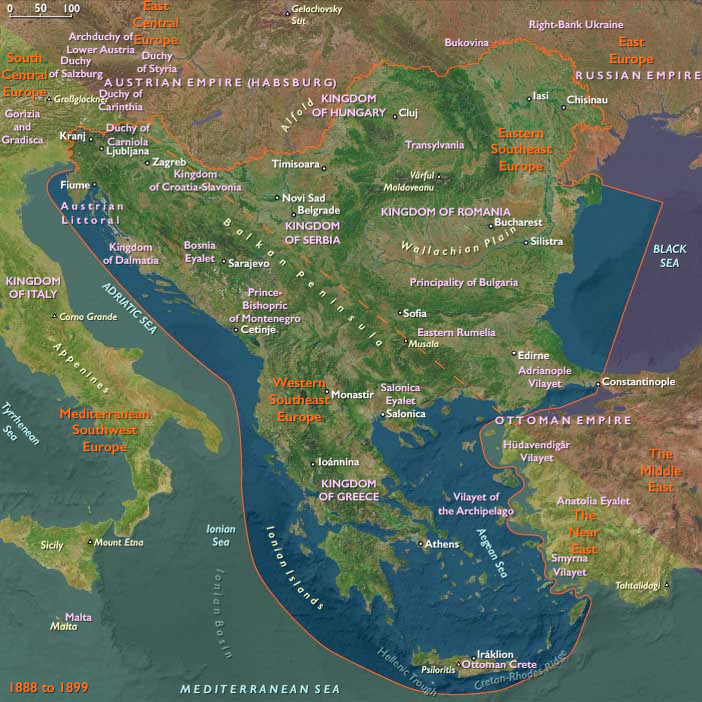
Western Southeast Europe (1828–1971 CE): From Borderlands of Empire to Tourism Coasts and Non-Aligned Experiments
Geography & Environmental Context
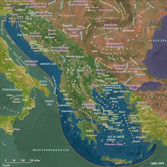
Western Southeast Europe includes Greece, Albania, Montenegro, North Macedonia, Kosovo most of Bosnia and Herzegovina, southwestern Serbia, most of Croatia, and Slovenia—the Aegean-facing and Adriatic–Ionian belts of the Balkans (the Aegean is included; the Black Sea is not). Anchors: the Dinaric Alps and Pindus ranges; the Vardar/Axios, Neretva, Drina, Sava, and Morava corridors; the Aegean and Adriatic archipelagos; the Peloponneseand Epirus; the karst coasts of Dalmatia; and urban hubs such as Athens–Piraeus, Thessaloniki, Zagreb, Split, Dubrovnik, Sarajevo, Skopje, Tirana, and Ljubljana.
Climate & Environmental Shifts
A Mediterranean-to-continental gradient shaped livelihoods: hot, dry summers on Aegean and Adriatic littorals; snowy winters across karst uplands and Alpine forelands. Drought pulses stressed olives, vines, and citrus; floods along the Sava–Drina and Neretva valleys periodically damaged fields and towns. Major earthquakes punctuated the era—most notably the Skopje earthquake (1963)—and volcanic–seismic activity in Greece periodically disrupted islands. Reforestation and river regulation expanded after 1945, while coastal wetlands were drained for malaria eradication and agriculture.
Subsistence & Settlement
-
Agrarian cores:
-
Greece: Olives, vines, wheat, and tobacco in Macedonia and Thessaly; citrus on the islands; pastoral transhumance in Epirus and Pindus.
-
Yugoslav lands (Slovenia, Croatia, Bosnia-Herzegovina, Montenegro, Macedonia, SW Serbia/Kosovo): Mixed grains, maize, vineyards (Slovenia, Dalmatia, Macedonia), and livestock; lowland sugar-beet and hops in Slovenian basins.
-
Albania: Wheat, maize, olives; citrus and figs in the south; collectivization after 1946 reshaped villages.
-
-
Urban growth: Athens expanded after 1922 with Asia Minor refugees; Thessaloniki, Zagreb, Ljubljana, Sarajevo, Skopje, Tirana, and Adriatic ports grew as administrative–industrial nodes. By the 1960s, resort towns on the Adriatic and Aegean coasts accelerated service-sector settlement.
Technology & Material Culture
Railways (Vienna–Ljubljana–Zagreb–Rijeka/Split; Salonica corridors) and steamship lines connected interior basins to ports. After 1945, Yugoslavia’s self-management system promoted steel, shipbuilding (Split, Rijeka), chemicals, and machine tools; Slovenia led in electronics and precision industries. Greece industrialized around textiles, cement, and refineries; Greek oceangoing shipping boomed (Onassis–Niarchos fleets). Albania pursued autarkic electrification and heavy industry under Hoxha. Everyday life shifted from stone farmhouses and zadruga kin compounds to concrete apartments; radios, scooters, and by the 1960s televisions appeared alongside mass tourism paraphernalia on the coasts.
Movement & Interaction Corridors
-
Imperial to national routes: Ottoman retreat and Habsburg decline gave way to Balkan states oriented to new capitals; the Treaty of Berlin (1878), Austro-Hungarian annexation of Bosnia (1908), and Balkan Wars (1912–13) re-charted corridors to Thessaloniki, Rijeka, Split, and Dubrovnik.
-
World wars & after: WWI began in Sarajevo (1914); interwar Yugoslavia centralized transport on the Sava–Danube axis; WWII occupation fractured networks, then partisan rebuilding re-stitched rail and roads.
-
Migration: Mass emigration to the Americas (19th–early 20th c.); post-1955 Gastarbeiter flows from Yugoslavia and Greece to West Germany, Switzerland, and France; internal rural-to-urban migration filled Athens, Zagreb, and Skopje.
-
Tourism & ferries: 1950s–60s charter flights and ferry lines linked the Dalmatian and Aegean coasts to Western Europe, inaugurating a sea-sun economy.
Cultural & Symbolic Expressions
A mosaic of languages and faiths—Orthodox, Catholic, and Muslim communities—coexisted and contended. Greek nationalism oscillated between constitutional monarchy, the Megáli Idéa (megáli idéa) of expansion, and republican currents; Yugoslav South-Slav ideas fused and fractured (Illyrian movement, then royal centralism, then socialist federalism under Tito after 1945). Music and letters spanned Greek rebetiko and laïkó, Macedonian and Dalmatian folk traditions, Sevdalinka in Bosnia, and Slovenian literary modernism; film and festivals (Dubrovnik Summer Festival) projected regional identities abroad. Urban cafés, seaside promenades, and mountain kermises provided shared civic stages.
Environmental Adaptation & Resilience
Terraces and dry-stone walls conserved thin soils on olive and vine slopes; tobacco rotations in Greek Macedonia buffered peasant incomes; karst irrigation and postwar dam projects moderated drought. Malaria eradication (drainage, DDT campaigns) opened lowlands to farming and tourism. Socialist Yugoslavia’s reforestation and flood control reduced hazard exposure; in Albania, forced collectivization increased irrigation but strained rural welfare. Coastal fisheries and smallholder gardens hedged urban food supply during crises.
Transition
From 1828 to 1913, Western Southeast Europe moved from imperial borderlands to nation-state mosaics (Greek consolidation, Austro-Hungarian rule in Slovenia–Croatia–Bosnia, Albanian independence in 1912). WWI shattered empires; interwar centralism struggled with regional diversity; WWII occupation and brutal civil conflicts (including the Greek Civil War, 1946–49) gave way to divergent Cold War paths: Yugoslavia’s non-aligned socialist federation, Greece’s Western alignment (and the 1967–74 junta beginning within our window), and Albania’s isolationist communism. By 1971, Adriatic and Aegean resorts, emigrant remittances, shipping fortunes, and socialist factories had reoriented livelihoods from subsistence terraces to a mixed economy—tourism, industry, and diaspora—while mountain villages and multi-faith cities still anchored the region’s layered identities.
Images

Western Southeast Europe (with civilization) ©2024-25 Electric Prism, Inc. All rights reserved.
Groups
Topics
Commodities
Subjects
Regions
Southeast Europe
View →Subregions