East Europe (1396–1539 CE): Forest Realms, Steppe…
1396 CE to 1539 CE
East Europe (1396–1539 CE): Forest Realms, Steppe Frontiers, and the Gathering of States
Geographic & Environmental Context
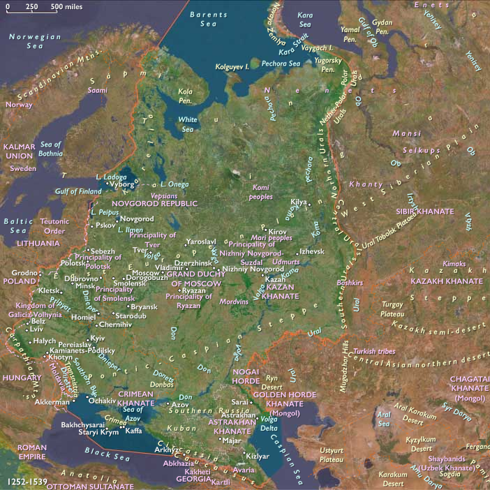
East Europe—the forest, forest-steppe, and steppe belt from the Baltic–Dvina–Vistula watershed through the Dnieper–Don–Oka–Upper Volga to the Ural forelands—was a region knitted by rivers rather than by a single political center.
Anchors included the Vistula–Bug–Niemen–Dvina corridors tying Ruthenian lands to the Baltic; the Dnieper running to the Black Sea; the Oka–Volga system binding Muscovy’s forests to the steppe; the Carpathian rim and Polish–Lithuanian uplands; and the Pontic marches exposed to Tatar raids. Three environmental “worlds” overlapped: the northern forest and lake country (Novgorod–Muscovy), the forest-steppe of Lithuania-Rus’ (Kiev, Vilnius, Smolensk), and the open steppe frontier facing the Golden Horde’s heirs—Crimea, Kazan, and Nogai.
Climate & Environmental Shifts (Little Ice Age)
Colder winters and erratic summers sharpened contrasts.
-
Forest zone: long freezes favored fur and wax trades; short growing seasons promoted rye, oats, and buckwheat.
-
Forest-steppe: bumper-failure swings in wheat and millet; spring floods and autumn droughts on the Dnieper and Don.
-
Steppe rim: grass cycles dictated cattle and horse movements; drought years magnified the impact of Crimean and Nogai raiding.
Households hedged climate risk with mixed plots, hay meadows, and riverine fishing; towns stockpiled grain and salt.
Subsistence, Settlement, & Economies
-
Countryside: slash-and-burn in the north; heavy-plow grain in the black-earth; flax and hemp for cordage; orchards and beekeeping in the forest-steppe.
-
Urban nodes: Novgorod (to 1478) and Pskov (to 1510) funneled furs, tallow, and wax to the Baltic; Smolensk–Polotsk–Vilnius sat on the Niemen/Dvina axis; Kyiv and Chernihiv waned under steppe pressure; Moscow, Tver, Yaroslavl, and Nizhny Novgorod rose on the Oka–Volga.
-
Mines & mints: silver and copper imports financed coinages; inland salt pans (e.g., Sol’ Vychegodskaya) and forest ironworks supplied regional markets.
-
Grain & cattle cycles: the Vistula–Danzig/Gdańsk route drew Polish-Lithuanian surpluses north; the upper Volga sent fish and grain south; steppe herds provisioned towns—when not seized in raids.
Technology & Material Culture
-
Agrarian–hydraulic: three-field rotations; river millwheels; ice-road logistics in winter.
-
Fortification & arms: timbered earthworks and kremlin complexes in stone/brick (Moscow’s Italian-built walls and cathedrals, 1470s–1500s); hand-guns and field artillery entered siege practice.
-
Statecraft & law: Muscovy’s Sudebnik (1497) curtailed peasant mobility to fixed terms (Yuri’s Day), inaugurating a longer serfdom trajectory; Lithuania’s First Statute (1529) codified Ruthenian-chancery law across a multi-confessional realm.
-
Print & script: Cyrillic and Ruthenian chancery hands dominated; Francysk Skaryna printed the Bible in Ruthenian (Prague 1517–19; Vilnius 1525), marrying humanist technique to Orthodox readership.
Movement & Interaction Corridors
-
Baltic–Hanse link: Novgorod–Pskov–Riga shipped forest products; after annexations (1478, 1510) Muscovy redirected flows through its own towns.
-
Dnieper run: limited outward movement under Crimean–Ottoman control of the Black Sea; frontier Cossack prototypes began to appear in the lower Dnieper marshes late in the period.
-
Oka–Volga arc: the service cavalry state of Muscovy rode these corridors to gather “Russian lands,” while guarding watches (stanitsy) against Tatar forays.
-
Carpathian passes: salt, wine, and cattle knit Ruthenia, Lithuania, Hungary, and Transylvania despite political fractures.
Cultural & Symbolic Expressions
-
Orthodoxy: icons, wooden churches, monastic networks (Trinity–Sergius, Kirillo-Belozersky) anchored the northern forest; Andrei Rublev’s school (c. 1400–1430s) set a canonical style.
-
Church politics: 1448—Moscow bishops asserted de facto autocephaly from Constantinople; marriage of Ivan III to Sophia Palaiologina (1472) nourished “Third Rome” idioms.
-
Heresy & reform: the Judaizer currents (late 15th c.) and the non-possessors vs. Josephites debate (Council 1503) contested monastic wealth and lay piety.
-
Ruthenian culture: Orthodox confraternities in Vilnius and Lviv sustained schools and charities; chancery Ruthenian served a multi-ethnic Lithuanian state; saints’ days and fairs marked urban calendars.
-
Court imagery: Muscovite architecture (Dormition, Annunciation, Archangel Cathedrals; Ivan the Great Bell Tower) projected a sacral monarchy.
Power & Conflict Dynamics
-
Golden Horde’s fragmentation: Timur’s blows (1395) and the rise of successor khanates (Crimea 1441; Kazan 1438; Great Horde’s eclipse 1502) reshaped the steppe.
-
Lithuania-Rus’ zenith and check: Vytautas’s reach faltered at Vorskla (1399); Grunwald/Tannenberg (1410)humbled the Teutonic Order; internal disputes after Vytautas (1430), then wars with Muscovy (1492–1503, 1507–08, 1512–22). Smolensk fell to Muscovy in 1514 despite the Lithuanian–Polish battlefield win at Orsha.
-
Muscovy’s ascent: Ugra standoff (1480) ended tribute to the Horde; Novgorod (1478) and Pskov (1510)annexed; gathering of the lands under Ivan III (1462–1505) and Vasili III (1505–1533) forged a centralized service state.
-
Tatar pressure: Crimean devastation of Moscow (1521) exposed Muscovy’s vulnerability; border militarization deepened along the Oka and in Severia.
-
Polish–Teutonic frontier: 1525—the Teutonic Order secularized into Ducal Prussia, a Polish fief, stabilizing the Baltic flank.
-
Ottoman vector: After 1475 Crimea fell under Ottoman suzerainty, projecting Istanbul’s power into the Black Sea; Moldavia and the Lower Danube became the hinge to Central Europe.
Environmental Adaptation & Resilience
-
Peasant strategies: grain rotations with legumes; beekeeping and forest by-products diversified diets; communal barns buffered bad years.
-
Town resilience: river granaries, tolls, and merchant credit moved surpluses across basins; monasteries provisioned in famine.
-
Frontier lifeways: watch-line settlements (zasadski) and fortified monasteries doubled as refuges; steppe ranching and winter camps adjusted to drought and raid cycles.
Subregional Signatures (in one view)
-
Northern Forest (Novgorod–Muscovy): from open mercantile republics to centralized autocracy, sacral monarchy, and service cavalry; legal consolidation (1497).
-
Lithuania-Rus’ Forest-Steppe: multi-confessional, Ruthenian-administrative realm buffering steppe shocks; codified law (1529); Baltic outward trade.
-
Pontic Steppe Rim: Crimean, Kazan, and Nogai vectors; raids and tribute systems shaping settlement density and military labor.
Each subregion shared as much with its external neighbors—the Baltic Hanse, the Ottoman Black Sea, the Central Asian steppe—as with one another, underscoring The Twelve Worlds premise that regions are envelopes; subregions are the living ecologies of history.
Transition by 1539
By the eve of mid-sixteenth century change, Muscovy had consolidated a powerful core but faced Crimean and Kazan threats; Lithuania-Rus’ retained vast lands yet had lost Smolensk and bled along the Oka and Dnieper; Poland–Lithuania prospered on Baltic grain routes while managing Teutonic transformation; the Black Sea remained an Ottoman-Crimean lake.
Printing, codification, and sacral kingship remade political imaginations; forts and service cavalry remapped the frontier. The next act—Kazan’s fall (1552), Livonian collapse (1558), and the Cossack frontier’s rise—was gestating along the same rivers that had long bound East Europe together.
Groups
Subjects
Regions
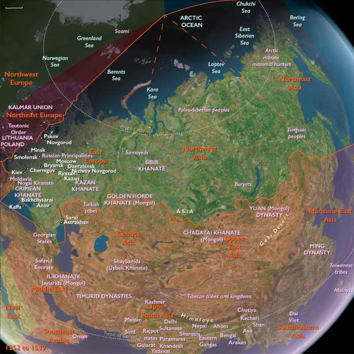
Northeastern Eurasia
View →Subregions