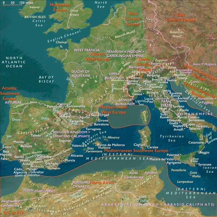
Mediterranean Southwest Europe (909 BCE–819 CE): Maritime…
909 BCE to 819 CE
Mediterranean Southwest Europe (909 BCE–819 CE): Maritime Integration, Roman Transformation, and Post-Imperial Reorganization
Geographic and Environmental Foundations
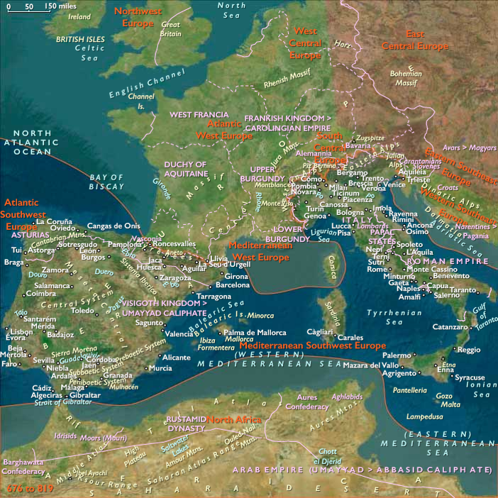
Mediterranean Southwest Europe includes the Italian Peninsula together with Sicily and Sardinia, Malta, the Balearic Islands, southern Portugal, southern, south-central, and eastern Spain, Andorra, and the central and eastern Spanish Pyrenees. It encompasses several interconnected but environmentally varied zones: the Alpine, Apennine, and Pyrenean mountain systems; the Po, Arno, Tiber, Ebro, Guadalquivir, Guadiana, and lower Tagus basins; the volcanic landscapes of central and southern Italy and eastern Sicily; the limestone uplands of southeastern Iberia and the Balearics; the high valleys and passes of Andorra and the central and eastern Spanish Pyrenees; the broad cereal plains of Sicily, Apulia, the Po Valley, Andalusia, and central Iberia; and a long chain of sheltered bays, lagoons, islands, and maritime passages extending from the Adriatic to the Strait of Gibraltar.
These landscapes formed neither a single ecological unit nor a uniform cultural region. Mountain ridges divided communities and impeded overland travel, while rivers, coastal plains, and sea-lanes connected them. The Italian Peninsula projected into the central Mediterranean; Sicily commanded the passages between Italy and North Africa; Sardinia and the Balearics linked the central and western basins; Malta occupied the corridor between Sicily and the African coast; and southern Iberia stood between the Mediterranean, Atlantic, and mineral-producing interior. The sea therefore acted less as a frontier than as the region’s principal transportation system.
Mediterranean climatic patterns—cooler, wetter winters and hot, dry summers—favored cereals, olives, vines, legumes, fruit trees, and seasonal pastoralism. Agricultural possibilities nevertheless varied considerably. Alluvial plains supported intensive grain production; terraced hillsides sustained vines and olives; mountain slopes and dry plateaus favored sheep, goats, pigs, and transhumant herding; wetlands and lagoons supplied fish, salt, reeds, and waterfowl; and wooded uplands provided timber, charcoal, resin, pasture, and protection. Volcanic soils could be exceptionally productive, although eruptions, earthquakes, erosion, drought, flooding, and irregular rainfall repeatedly disrupted local communities.
Indigenous Landscapes and Expanding Maritime Networks
At the beginning of the epoch, Mediterranean Southwest Europe contained numerous regional societies rather than consolidated territorial states. Villanovan communities occupied parts of northern and central Italy, while Etruscan, Latin, Sabine, Umbrian, Samnite, and other Italic identities developed through changing alliances, settlement patterns, and exchange systems. Sardinia retained strong Nuragic traditions; Sicily contained Sicel, Sican, Elymian, Phoenician, and emerging Greek communities; and southern and eastern Iberia supported Tartessian, Iberian, and other locally organized societies. These cultures were connected by movements of metals, salt, livestock, ceramics, textiles, timber, amber, grain, oil, wine, and prestige goods.
From the ninth and eighth centuries BCE, Phoenician merchants and settlers developed coastal stations and towns in southern Iberia, Sardinia, western Sicily, Malta, and the Balearics. Greek settlements appeared in southern Italy and eastern Sicily from the later eighth century BCE, creating the urban and agricultural networks conventionally called Magna Graecia. These movements did not simply replace indigenous populations. They created mixed coastal environments in which imported practices—alphabetic writing, new ceramic forms, coinage, monumental building, specialized craft production, and intensified maritime commerce—were adapted within older local systems. Archaeological evidence likewise shows sustained contact among northern and southern Italy, Sicily, and neighboring islands, while Etruscan culture emerged from Villanovan foundations amid strong interaction with Greek and other Mediterranean communities.
Maritime colonies initially depended upon nearby fields, fisheries, anchorages, and relations with inland communities. Their importance lay not only in urban growth but in their capacity to connect previously separate ecological zones. Metals from Iberia and Sardinia, grain from Sicily and southern Italy, timber and livestock from uplands, and manufactured goods from coastal workshops moved through networks of small harbors and island stopping points. Over time, some coastal settlements became powerful cities, but their endurance continued to depend upon surrounding agricultural territories and regional exchange.
Urbanization, Territorial Competition, and Regional Consolidation
Between the seventh and fourth centuries BCE, settlement hierarchies became more pronounced. Etruscan cities coordinated surrounding farms, roads, sanctuaries, mines, and river routes across much of central Italy. Greek city-states developed extensive agricultural territories in southern Italy and Sicily. Phoenician communities in western Sicily, Sardinia, the Balearics, and southern Iberia became increasingly connected to Carthage, while indigenous Iberian communities organized around fortified settlements, productive valleys, and long-distance exchange. Written languages, coinage, formal civic institutions, and increasingly specialized workshops spread unevenly through the region.
The growth of cities did not eliminate village agriculture, pastoral mobility, or local autonomy. Most people continued to live within landscapes of farms, hamlets, seasonal grazing grounds, and small market centers. Political competition was expressed through control of fertile plains, mountain passes, river crossings, ports, metal-producing districts, and maritime choke points. Sicily became a particularly contested environment because its agricultural wealth and central location drew Greek, Punic, and indigenous powers into prolonged interaction and warfare.
Rome emerged from the network of settlements surrounding the lower Tiber. Its position near a river crossing and between inland routes and the Tyrrhenian coast gave it access to agricultural, pastoral, and maritime systems. Through warfare, alliance, colonization, road construction, and differentiated grants of political status, the Roman Republic gradually incorporated neighboring Latin, Etruscan, Samnite, Greek, and other Italian communities. The process did not produce immediate cultural uniformity; rather, it created a layered territorial system in which local elites, towns, colonies, military obligations, and transport corridors were increasingly coordinated from Rome.
Roman Expansion and Mediterranean Integration
Between the third and first centuries BCE, conflicts with Carthage transformed the regional balance. Sicily, Sardinia, Mediterranean Iberia, and the Balearic sea-lanes became incorporated into an expanding Roman political and military system. Roman conquest in Iberia was prolonged and uneven, advancing through river valleys, coastal plains, mining areas, fortified towns, and military roads while repeatedly encountering indigenous resistance. In Italy, the extension of Roman citizenship and municipal structures gradually bound formerly independent communities into a more integrated peninsula.
Roman expansion reorganized rather than invented the region’s economic networks. Existing Phoenician, Punic, Greek, Etruscan, Iberian, and indigenous routes were connected to a wider system of roads, ports, taxation, military supply, and urban demand. Agricultural estates expanded in some districts, while smallholders, tenants, pastoralists, and village communities remained essential elsewhere. Mining intensified in Iberia and Sardinia. Grain, olive oil, wine, salted fish, metal, ceramics, stone, timber, and livestock circulated among Italy, Iberia, the islands, North Africa, Gaul, and the eastern Mediterranean.
The political crises of the late Republic were closely linked to these territorial transformations. Military mobilization, unequal landholding, enslavement, provincial taxation, elite competition, and the concentration of wealth destabilized republican institutions. Civil wars brought armies repeatedly through Italy, Sicily, Sardinia, and Iberia. The establishment of Augustus’s principate transformed Rome from the leading city of an expansionist republic into the administrative center of an imperial Mediterranean.
Imperial Landscapes and Economic Specialization
From the late first century BCE through the second century CE, Roman rule produced the epoch’s most extensive integration of Mediterranean Southwest Europe. Roads crossed mountains and plains; bridges and way stations supported official and commercial movement; harbors and coastal anchorages connected regional markets; and cities coordinated taxation, craft production, administration, religion, and exchange. Roman economic life depended upon interconnected land and sea routes linking urban centers with agricultural and mineral-producing hinterlands.
Italy remained the empire’s political and symbolic center, but its regions developed differently. The Po Valley combined cereal production, livestock, river transport, and connections across the Alpine passes. Central Italy supported dense networks of towns, estates, roads, vineyards, olive groves, and administrative institutions. Southern Italy and Sicily retained strong maritime and agricultural roles, while Sardinia supplied grain, minerals, livestock, and coastal products. Malta and the Balearics functioned as island nodes within longer shipping routes.
Hispania became deeply integrated into imperial production and exchange. The Guadalquivir valley and Mediterranean southeast produced large quantities of olive oil, wine, grain, and fish products; mining districts supplied silver, copper, lead, and other metals; and river and coastal ports connected estates and towns to the wider empire. Southern Portugal participated through the lower Tagus, Guadiana, Algarve, and Atlantic–Mediterranean coastal systems. Amphorae, ceramics, inscriptions, roads, aqueducts, bridges, warehouses, presses, and fish-processing installations reflected increasingly specialized regional economies.
Imperial prosperity remained ecologically dependent. Grain production required the maintenance of plains and drainage systems; olive and vine cultivation depended upon long-term investment in terraces, presses, storage, and transport; mining consumed timber and labor; and cities relied upon rural water, fuel, food, and building materials. The apparent dominance of monumental urban architecture therefore rested upon dispersed landscapes of farms, villages, workshops, quarries, forests, pastures, wetlands, and ports.
Cultural and Institutional Transformation
Roman political integration accelerated linguistic and cultural exchange but did not erase regional identities. Latin became dominant across Italy and much of Iberia, while Greek remained influential in southern Italy, Sicily, and eastern Mediterranean commerce. Punic, Iberian, Etruscan, and other languages persisted for varying periods before declining or being absorbed into wider linguistic systems. Local religious practices continued alongside Roman civic cults, imported deities, household traditions, and emperor worship.
Christian communities appeared within this plural religious environment and expanded gradually through cities, ports, roads, and social networks. Their institutional growth became especially important during the third and fourth centuries, when bishops, clergy, charitable foundations, cemeteries, and places of worship acquired increasingly visible roles. Imperial support after Constantine accelerated church construction and ecclesiastical organization, but Christianization remained uneven and extended over generations. Rural cults, household practices, Jewish communities, philosophical traditions, and regional religious identities continued alongside expanding Christianity.
The fourth century saw the growth of churches, episcopal centers, monasteries, and Christian patronage within landscapes still structured by Roman roads, cities, estates, and taxation. Rather than simply ending classical society, Christianity adapted many inherited urban, legal, artistic, and administrative forms. Bishops increasingly acted as intermediaries between imperial authorities, local elites, and urban populations.
Crisis, Adaptation, and Regional Divergence
From the third century onward, political instability, warfare, epidemic disease, inflation, heavier taxation, and changing trade patterns placed growing pressure on Roman institutions. These disruptions did not affect all parts of the region equally. Some towns contracted, while others retained commercial or administrative importance. Certain estates disappeared or fragmented; others became larger or more defensible. Coastal exchange continued, though its routes, scale, and principal suppliers changed. Villages, fortified sites, monasteries, episcopal centers, and regional ports assumed greater importance as centralized imperial systems weakened.
The formal division of the Roman Empire and the collapse of western imperial government during the fifth century did not immediately destroy Roman landscapes. Roads, ports, aqueducts, agricultural terraces, legal traditions, taxation practices, Latin literacy, and Christian institutions survived in altered forms. New rulers generally governed through combinations of military households, Roman administrators, local landowners, bishops, and established cities.
In Italy, Ostrogothic rule preserved much of the Roman administrative framework before Justinian’s armies attempted to restore direct imperial control. The prolonged Gothic War damaged settlements, agriculture, and transportation networks in many districts. Byzantine victory was followed by Lombard migration and conquest from 568, dividing the peninsula among Lombard kingdoms and duchies, Byzantine territories, papal lands, and locally autonomous coastal communities. By the eighth century, northern and central Italy contained Lombard, papal, Byzantine, and eventually Carolingian political systems, while southern Italy and Sicily remained more closely connected to Byzantium. The chronology of the peninsula shows this enduring regional fragmentation: Lombard rule dominated much of northern Italy until 774, Byzantine authority persisted in parts of the peninsula and Sicily, and Carolingian and papal territories expanded during the later eighth century.
Sardinia, Sicily, Malta, and the Balearics remained exposed to shifting naval power because island government depended upon shipping, coastal defense, and communication with distant capitals. Vandal rule in parts of the western Mediterranean was followed by Byzantine reconquest, but imperial control varied in intensity. Local landholding, episcopal institutions, fortified ports, and island communities mediated between external governments and enduring agricultural systems.
Visigothic Iberia and the Formation of Al-Andalus
In Iberia, Suevic, Vandal, Byzantine, and especially Visigothic powers emerged from the disintegration of western Roman rule. The Visigothic kingdom gradually established authority over most of the peninsula while preserving much Roman law, taxation, urban organization, and ecclesiastical administration. Political power remained unstable, however, and varied significantly between the royal center, provincial elites, bishops, cities, rural estates, and frontier districts.
The conversion of the Visigothic monarchy from Arian to Catholic Christianity in the late sixth century strengthened cooperation between rulers and the Hispano-Roman episcopate. Councils, monasteries, churches, and cathedral centers became important institutions of governance, education, landholding, and social assistance. Yet rural and regional differences persisted, and neither royal authority nor ecclesiastical organization produced complete uniformity.
The Muslim conquest beginning in 711 rapidly displaced the Visigothic monarchy but did not replace the existing population or agricultural landscape. Arab and Berber armies established authority through conquest, treaties, taxation, garrisons, and accommodation with local elites. Many cities, estates, roads, irrigation works, and Christian communities continued under new political conditions. From 756, the independent Umayyad emirate centered at Córdoba began consolidating control over al-Andalus, although authority remained contested in frontier districts and among regional factions. The peninsula between 500 and 1000 underwent successive Visigothic, Byzantine, and Islamic political transformations, accompanied by substantial interaction among Christian, Jewish, and Muslim populations.
By 819, southern, south-central, and eastern Iberia had become core territories of al-Andalus, while southern Portugal participated through the Guadiana, lower Tagus, Algarve, and Atlantic-facing ports. Islamic governance initially adapted late Roman and Visigothic fiscal, urban, and agricultural foundations. New political and commercial connections increasingly oriented Iberian ports toward North Africa and the broader Islamic Mediterranean, but the fuller transformation of irrigation, crops, urban crafts, and rural settlement unfolded gradually beyond the endpoint of this epoch.
Maritime Corridors and Enduring Regional Systems
The central and eastern Pyrenees formed both a barrier and a connective frontier, with high valleys, seasonal pasturelands, river corridors, and passes linking northeastern Iberia to Mediterranean Gaul and the wider trans-Pyrenean world. Andorra belonged to this mountain system, where pastoral mobility, woodland use, small-scale cultivation, and control of passes remained more historically important than urban development.
Across the entire epoch, the sea remained the most consistent organizing force. Political centers rose and fell, but shipping continued to link Italy, Sicily, Sardinia, Malta, the Balearics, Iberia, North Africa, Gaul, and the eastern Mediterranean. Maritime transport moved bulk goods more efficiently than overland routes, while islands supplied stopping places, sheltered anchorages, pilots, ship timber, sailors, fish, salt, grain, and livestock.
Overland corridors remained essential to the sea-based system. Alpine passes connected the Po Valley with transalpine Europe. The Apennine valleys linked Italy’s Adriatic and Tyrrhenian coasts. The Tiber joined inland central Italy to Rome and Ostia. The Ebro connected the Mediterranean coast to northeastern Iberia, while the Guadalquivir, Guadiana, and Tagus linked agricultural and mineral-producing interiors with southern and western ports. Roman roads intensified these connections, but many followed routes established by earlier communities.
The region’s political importance arose from this interaction of fragmented landforms and connective waters. No single city, empire, or religion permanently controlled the whole subregion. Even at the height of Roman power, local production and regional exchange remained environmentally differentiated. After Roman unity dissolved, the same valleys, ports, islands, plains, and mountain corridors supported Byzantine, Lombard, Visigothic, papal, Carolingian, and Umayyad systems.
Legacy of the Epoch
Between 909 BCE and 819 CE, Mediterranean Southwest Europe developed from a mosaic of indigenous agricultural, pastoral, and maritime societies into one of the ancient world’s most densely connected regions, passed through centuries of Roman territorial integration, and then reorganized into a politically plural early medieval landscape.
The epoch’s most consequential transformation was not simply the rise and fall of Rome. It was the progressive coordination of ecological systems: cereal plains, terraced hillsides, pastoral uplands, mines, forests, rivers, roads, ports, islands, and sea-lanes. Phoenician, Greek, Etruscan, Punic, Iberian, Roman, Christian, Germanic, Byzantine, Islamic, and Frankish institutions successively adapted these systems without wholly replacing them.
By 819, the political unity of the Roman Mediterranean had disappeared, but much of its environmental and infrastructural inheritance remained. Northern and central Italy were divided among Carolingian, papal, Lombard, Byzantine, and autonomous regional authorities; southern Italy and Sicily remained strongly connected to Byzantium; and much of southern and eastern Iberia belonged to the Umayyad emirate of Córdoba. Across these divisions, agriculture, pastoralism, fisheries, craft production, monastic and episcopal institutions, ports, roads, and coastal exchange continued to sustain regional life.
The defining historical image of Mediterranean Southwest Europe is therefore not Rome, Córdoba, a temple, a cathedral, or a royal court. It is a distributed Mediterranean landscape in which mountain communities, river plains, island ports, coastal cities, terraced farms, grazing uplands, and maritime routes repeatedly reorganized themselves around changing systems of power while preserving an enduring environmental continuity.
Groups
Commodities
Regions
Southwest Europe
View →Subregions