North Africa (909 BCE – 819 CE)…
909 BCE to 819 CE
North Africa (909 BCE – 819 CE) Early Iron and Antiquity — Phoenicians and Carthage, Numidian–Mauretanian Kingdoms, Rome, Garamantes, and Late Antique Transitions
Geographic and Environmental Context
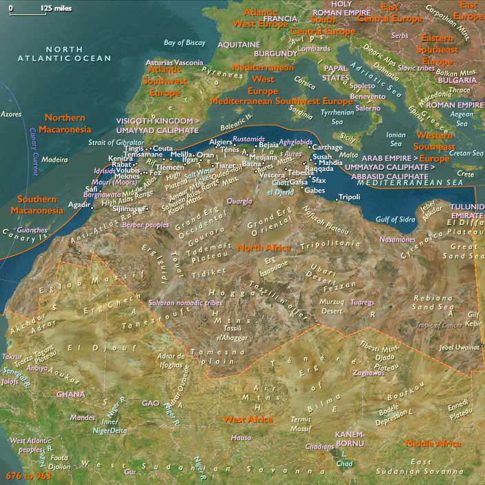
North Africa includes Morocco, Algeria, Tunisia (Ifriqiya), Libya (Tripolitania–Fezzan–Cyrenaica), and Western Sahara.Anchors: the Atlas ranges (High/Middle/Anti-Atlas; Tell Atlas; Aurès), the Tell and Sahel coasts (Atlantic Morocco, Rif/Alboran, Kabylia, Ifriqiya, Syrte/Gulf of Sidra, Cyrenaica), the Saharan platforms and sand seas (Erg Chech, Grand Erg Occidental & Oriental, Tanezrouft), the oases and basins (Tafilalt, Draâ, Touat–Gourara–Tidikelt, M’zab, Wadi Igharghar, Fezzan (Wadi al-Ajyal, Ubari and Murzuq dunes)), and the trans-Saharan corridors toward Lake Chad, Niger Bend, and the Nile.
-
Coasts: Phoenician and later Punic ports (Carthage, Utica, Hippo Regius, Leptis Magna, Sabratha, Oea/Tripoli, Lixus, Mogador); Greek Cyrenaica (Cyrene).
-
Interior: Garamantes in Fezzan; Numidia (Aurès–Constantine) and Mauretania (Rif–Atlas) uplands.
Climate & Environmental Shifts
-
Mediterranean coasts temperate; interior arid but stable around engineered oases.
Societies & Political Developments
-
Phoenician colonization (from 9th–8th c. BCE) culminated in Carthage (trad. 814 BCE); Punic hegemony fostered trade and urbanism.
-
Numidian and Mauretanian kingdoms crystallized (2nd–1st c. BCE), later client to Rome; Cyrenaica Greek cities flourished in the east.
-
Rome created Africa Proconsularis, Numidia, Mauretania Caesariensis/Tingitana, Tripolitania, Cyrenaica; roads, aqueducts, ports (grain, olive oil, garum).
-
Garamantes (ca. 500 BCE–500 CE) dominated Fezzan, controlling desert trade with foggaras, walled towns, and chariot/camel trails.
-
Late Antiquity: Vandals (5th c. CE) seized coastal Africa; Byzantines reconquered (6th c.); Berberconfederacies expanded inland; Islamic polities advanced in the 7th–8th c. CE, establishing Kairouan and early dynasties; by the 8th–9th c., Idrisids rose in Morocco.
Economy & Trade
-
Coastal exports: grain, olive oil, wine, salted fish, purple dye; interior trade: salt, dates, gold, slaves, ivory; oasis produce and transshipment (Fezzan, Touat).
-
Caravan systems matured between Fezzan ↔ Niger Bend/Lake Chad and Tripolitania/Cyrenaica ↔ Nile.
Technology & Material Culture
-
Iron widespread; Roman engineering (roads, bridges, aqueducts; port moles).
-
Oasis technologies: foggaras/khettaras, cisterns, terrace gardens; wheel-made ceramics, glass.
-
Urban mosaics, Punic and Roman inscriptions; desert fortlets and tumuli fields.
Belief & Symbolism
-
Punic religion (Baal Hammon–Tanit) across ports; Greek/Roman polytheism then Christianity in cities; Judaism in port communities;
-
Amazigh (Berber) cults of springs, mountains, and ancestors persisted; Garamantian funerary landscapes extensive; Islam spread in the late centuries of this epoch.
Environmental Adaptation & Resilience
-
Coastal breadbasket + oasis waterworks + caravan redundancy ensured stability; mixed agrarian–pastoral portfolios buffered shocks.
Transition
By 819 CE, North Africa was a polycentric frontier: Punic–Roman urban legacies, Garamantian oasis know-how, and rising Islamic–Amazigh polities formed the launching pad for the 9th–14th-century Almoravid, Almohad, Marinid/Hafsid/Zayyanid transformations to come.
Groups
Topics
Commodities
Subjects
Regions
North Africa
View →Subregions
